Bovingdon
| Bovingdon | |
| Hertfordshire | |
|---|---|
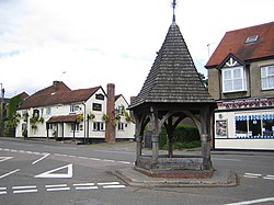
 Bovingdon High Street | |
| Location | |
| Grid reference: | TL013037 |
| Location: | 51°43’23"N, -0°31’56"W |
| Data | |
| Postcode: | HP3 |
| Dialling code: | 01442 |
| Local Government | |
| Council: | Dacorum |
| Parliamentary constituency: |
South West Hertfordshire |
Bovingdon is a large village in the Chiltern Hills, in Hertfordshire, four miles southwest of Hemel Hempstead.
The village is mediæval in origin but it has expanded significantly since the 1940s. It now has a large commuter population. The old parts of the village are mostly around the High Street and the Green.
The name of Bovingdon is first mentioned in deeds from 1200 as Bovyndon. It could originate from Old English Bufan dune meaning "above the down" or from Bofa's Down, from an otherwise unknown landlowner or chieftain.
Churches

- Church of England: St Lawrence
- Baptist: Bovingdon Baptist Church
St Lawrence Church was built in 1845 by Talbot Bury. The churchyard is the second largest in Hertfordshire and includes an avenue of clipped yew trees. The vicar also serves as chaplain to the Mount, the prison outside the village.
The Baptist church was built for a Wesleyan Methodist congregation and later sold to the Baptists.
About the village
Bovingdon has several old cottages of interest. There are two pubs in the village centre, The Bull and The Bell. A third, the Wheatsheaf, is now closed.
The Bobsleigh Inn on Box Lane, just east of the village, is a large house with some parts dating to the sixteenth century which is now a hotel and restaurant. It was the Bovingdon Country Club until 1964 when Tony Nash, the son of the owner, was part of the gold medal winning British two man bobsleigh team at the 1964 Winter Olympics at Innsbruck in Austria. It was renamed the Bobsleigh Inn in his honour. During the Second World War many celebrities stayed at the Country Club while entertaining troops at the nearby airbase, including Bob Hope, James Stewart and Glenn Miller.
Bovingdon airfield and The Mount Prison
Next to Bovingdon is the disused former Second World War, Eighth Air Force and post-war Royal Air Force airfield, RAF Bovingdon.
The airfield was built in 1942. Between 1943 and 1946 it became a B-17 operational training base for units such as 92nd Bomber Group, B-17 Flying Fortress Combat Crew Replacement Centre (CCRC), 11th CCRC, and 8th USAAF HQ Squadron. The RAF resumed control until 1951, then the USAF took over again until 1962 flying B-26 Marauders, B-29 Superfortresses, and B-50 Superfortresses. General Dwight D. Eisenhower's personal aircraft was said to be based here, as Bovingdon was the closest Eighth Air Force base to London.
Flying ceased in 1969, though some flying scenes for the film Hanover Street were shot there in 1978. The field served as airport for Hemel Hempstead during most of the postwar period.
Several films were made at Bovingdon airfield including The War Lover, 633 Squadron, Hanover Street, an episode of the Persuaders,The Man With The Golden Gun (the flying car scene) and Mosquito Squadron.
The airfield site houses a VOR navigational beacon, code BNN. The airspace above the airfield and nearby Chesham is known as the Bovingdon stack and is a holding area for aircraft approaching Heathrow Airport, 20 miles to the south. At busy times on a clear day a dozen planes circle.
Part of the airfield was used to build The Mount Prison during the 1980s; it was located on the site of the aircraft hangars and administration blocks. The remainder of the site is used for a Saturday market and there is a permanent circuit for banger racing although there has not been any regular racing since 2008. The airfield is also a site for paintballing.
Of the three original runways, the North East/South West runway is still complete, and used for parking on market days.
The North West/South East runway is completely gone. The East/West runway is still complete, the Eastern end of which is used for the weekend Market, the Western end used to be used by the Farmers aircraft. The control tower still exists, but is in a very poor state. A lot of the taxiways, and the 2nd World War Bomb Dump trackways are mostly gone, a victim of hardcore reclamation, a common end of a large number of disused airfields in the UK.
Outside links
| ("Wikimedia Commons" has material about Bovingdon) |
