Treginnis
| Treginnis | |
| Pembrokeshire | |
|---|---|
 Treginnis Isaf | |
| Location | |
| Grid reference: | SM724239 |
| Location: | 51°52’4"N, 5°18’25"W |
| Data | |
| Postcode: | SA62 |
| Local Government | |
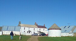
Treginnis is a pair of tiny hamlets in Pembrokeshire, a mile and a half south-west of St Davids, at the end of the broad peninsula on which that pocket-city stands. The two portions are Treginnis Isaf (Lower Treginnis) and Treginnis Uchaf (Upper Treginnis).
Treginnis is by Pen Dal-aderyn, the headland that forms the westernmost point of the mainland of Pembrokeshire and of Wales. Accordingly, this hamlet is the westernmost settlement of Wales.
The hamlet, and much of the land around is within an estate owned by The National Trust, and is all within the Pembrokeshire Coast National Park. A few hundred to the west of Pen Dal-aderyn lies Ramsey Island.
| ("Wikimedia Commons" has material about Treginnis) |
