Britwell Salome
| Britwell Salome | |
| Oxfordshire | |
|---|---|
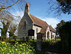
 St Nicholas, Britwell Salome | |
| Location | |
| Grid reference: | SU670929 |
| Location: | 51°37’54"N, 1°1’58"W |
| Data | |
| Population: | 204 (2011) |
| Post town: | Watlington |
| Postcode: | OX49 |
| Dialling code: | 01491 |
| Local Government | |
| Council: | South Oxfordshire |
| Parliamentary constituency: |
Henley |
Britwell Salome is a village in Oxfordshire, a mile and a half south-west of Watlington, and four and a half miles north-east of Wallingford, the latter across the river in Berkshire.
The 2011 Census recorded the parish's population as 204.
The suffice "Salome" is derived from the surname Sulham: there is a Berrick Salome about three miles to the west, and a Sulham near Reading in Berkshire.
Manor and estate
The Domesday Book records that before the Norman Conquest the manor was held by Wulfstan, who also held three others in the area including Adwell. It further records that by 1086 Britwell had been granted to the Norman Miles Crispin,[1] the first castellan of Wallingford Castle.
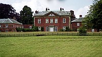
Britwell House was built in 1727–1728 for Sir Edward Simeon. The architect is unknown but Simeon himself designed the oval chapel, added in 1769.[2] In front of the house to the southeast is a freestanding neoclassical column, with a large stone urn as a finial. It was built for Sir Edward Simeon in 1764 as a monument to his parents.[3] In Britwell Park, north of the house, is a limestone obelisk with a pineapple finial. It too was erected for Sir Edward Simeon in the middle of the 18th century.[4] The house, monument and obelisk are all Grade II* listed buildings.[3][4][5]

Parish church
The Church of England parish church of St Nicholas was built early in the 12th century, and has a late 13th-century east window.[6] In 1865–67 the church was rebuilt to designs by the Gothic Revival architect Charles Buckeridge.[2] There was a church at Britwell Priors north-east of the village, but despite an objection from the Oxford Diocesan architect George Edmund Street it was demolished, and Buckeridge re-used some of its materials in the rebuilding of St Nicholas.[7] St Nicholas' parish is now part of the Benefice of Icknield, along with the parishes of Pyrton, Swyncombe and Watlington.
About the village
The local pub is the Red Lion, built late in the 18th or early 19th century.[8] The Tithe Commissioners met here in 1841.[1]
South-east of the village is Britwell Hill, over which runs the Ridgeway. There is a view of the Vale of Oxford looking down from the straight road that links the hill and the village.
Sport
- Cricket: Britwell Salome Cricket Club[9]
Outside links
| ("Wikimedia Commons" has material about Britwell Salome) |
References
- ↑ 1.0 1.1 Lobel 1964, pp. 43–55.
- ↑ 2.0 2.1 Sherwood & Pevsner 1974, p. 486
- ↑ 3.0 3.1 National Heritage List 1059462: Britwell Park, monument south west of Britwell House (Grade II* listing)
- ↑ 4.0 4.1 National Heritage List 1059461: Britwell Park, obelisk north of Britwell House (Grade II* listing)
- ↑ National Heritage List 1059503: Britwell House and attached walls and coach house (Grade II* listing)
- ↑ National Heritage List 1059466: Church of St Nicholas (Grade II listing)
- ↑ Saint 1973, p. 367.
- ↑ National Heritage List 1059472: The Red Lion Inn public house (Grade II listing)
- ↑ Britwell Salome Cricket Club
- A History of the County of Oxford - Volume 8 pp 43-55: Parishes: Britwell Salome (Victoria County History)
- Saint, Andrew (1973). "Charles Buckeridge and His Family". Oxoniensia (Oxfordshire Architectural and Historical Society) XXXVIII: 357–372. http://oxoniensia.org/volumes/1973/saint.pdf.
- Nikolaus Pevsner: The Buildings of England: Oxfordshire, 1974 Penguin Books ISBN 978-0-300-09639-2
