Deene
| Deene | |
| Northamptonshire | |
|---|---|
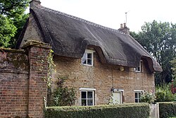
 Cherry Tree Cottage, Deene | |
| Location | |
| Grid reference: | SP947926 |
| Location: | 52°31’26"N, -0°36’17"W |
| Data | |
| Post town: | Corby |
| Postcode: | NN17 |
| Dialling code: | 01780 |
| Local Government | |
| Council: | North Northamptonshire |
| Parliamentary constituency: |
Corby |
Deene is a small village in Northamptonshire. Its name describes its location: it simply means 'Valley'.[1] The village is less than a mile north-west of Deenethorpe and a mile south-west of Bulwick
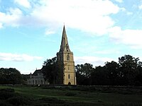
The old parish church, St Peter's Church, has been declared redundant.
There is a village hall.
Extending broadly over the valley, along the south side of the village and beyond, is the manor and estate of Deene Park.
Outside links
| ("Wikimedia Commons" has material about Deene) |
References
- ↑ Place-Names


This Northamptonshire article is a stub: help to improve Wikishire by building it up.
