Skaw, Unst
| Skaw | |
| Shetland | |
|---|---|
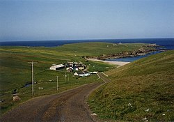
 The beach of Skaw | |
| Location | |
| Grid reference: | HP657163 |
| Location: | 60°49’30"N, -0°47’28"W |
| Data | |
| Post town: | Shetland |
| Postcode: | ZE2 |
| Dialling code: | 01806 |
| Local Government | |
| Council: | Shetland |
| Parliamentary constituency: |
Orkney and Shetland |
Skaw is a hamlet on Unst, the northernmost inhabited island of Shetland. The hamlet is to the north of Haroldswick, on a peninsula (which gives the hamlet its name) in the north-east corner of the island: this makes it the most northerly settlement in the United Kingdom.[1] It is currently inhabited by a single inhabitant whose business is sheep farming.
The Burn of Skaw flows from the uplands to the west through the constellation of small crofts that make up Skaw, and then east into the Wick of Skaw, a bay of the North Sea. A sheltered sandy beach lines the coast of the Wick of Skaw. The unclassified road (Holsens Road) from the B9087 to Skaw is the most northerly road in the United Kingdom road network, and the northernmost road in the world to use left-hand traffic.
Name
Skaw is derived from the Old Norse "Skagi" meaning a cape, headland, promontory or peninsula.[2][3]

History
Walter Sutherland (who died around 1850), was a former inhabitant of the northernmost cottage in Britain, and was reportedly the last native speaker of the Norn language.
During Second World War, the Royal Air Force built a Chain Home radar station at Skaw. The radar station was built in 1941 and closed in 1947. It was part of the defences of the RAF Sullom Voe flying boat base.
A combined Coastal Defence U-boat and Chain Home Low station was also built during the Second World War at Saxa Vord; after the war this became a ROTOR radar station. RAF Saxa Vord continued as a radar station after the end of the ROTOR programme.
The settlement is near the SaxaVord Spaceport being developed on Lamba Ness.[4]
See also
Outside links
| ("Wikimedia Commons" has material about Skaw, Unst) |
References
- ↑ "Overview of Skaw". Scottish Places. http://www.scottish-places.info/towns/townfirst35256.html.
- ↑ Jakobsen, Jakob (1993). The Place-Names of Shetland (reprint of 1897 ed.). Orkney. p. 96. ISBN 978-1112000461.
- ↑ Stewart, John (1987). Shetland Place-names. Lerwick. p. 246.
- ↑ "Proposed Development, Rev. E". 24 September 2020. https://consultation.shetlandspacecentre.com.
