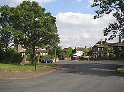
Scholes, Cleckheaton
| Scholes | |
| Yorkshire West Riding | |
|---|---|
 Town Gate, Scholes | |
| Location | |
| Grid reference: | SE167259 |
| Location: | 53°43’48"N, 1°44’54"W |
| Data | |
| Post town: | Cleckheaton |
| Postcode: | BD19 |
| Dialling code: | 01274 |
| Local Government | |
| Council: | Kirklees |
Scholes is a village near Cleckheaton, the West Riding of Yorkshire.
The village is five miles south of Bradford between Wyke and Cleckheaton near to the M62 motorway.

The village was originally known as "Scales" and was a hamlet in the township of Cleckheaton. In the 18th century the most prominent industry in the village was "card making" (combing cotton or linen.). Later on a Coal mine opened in the area but that closed early in the 20th century.
Outside links
| ("Wikimedia Commons" has material about Scholes, Cleckheaton) |
