North Rigton
| North Rigton | |
| Yorkshire West Riding | |
|---|---|
 North Rigton | |
| Location | |
| Grid reference: | SE279492 |
| Location: | 53°56’19"N, 1°34’29"W |
| Data | |
| Population: | 460 |
| Post town: | Leeds |
| Postcode: | LS17 |
| Dialling code: | 01423 |
| Local Government | |
| Council: | North Yorkshire |
| Parliamentary constituency: |
Skipton and Ripon |
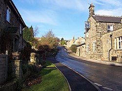
North Rigton is a village in the West Riding of Yorkshire, two miles south of Harrogate. The population of the parish was recorded as 460 in 2011.
Until the 19th century the village was known as Rigton,[1] the official name of the parish until 1962.[2] "North" was added to distinguish the place from East Rigton, seven miles to the south-east.[3] The name is from the Old English hrycg tun, meaning "farmstead on the ridge".
The place appears in the Domesday Book as Riston.[4]
The village was historically a township in the parish of Kirkby Overblow.
On television
Almscliffe Crag adjacent to the village was used for scenery at the end of Yorkshire Television dramas, The Beiderbecke Affair, The Beiderbecke Tapes and The Beiderbecke Connection. The area was never referred to by name.
Outside links
| ("Wikimedia Commons" has material about North Rigton) |
References
- ↑ Lewis's Topographical Dictionary of England (1835) cited on GENUKI
- ↑ Vision of Britain website
- ↑ Watts, Victor, ed. (2010), "Rigton", The Cambridge Dictionary of English Place-Names, Cambridge University Press
- ↑ Smith, A. H. (1961). The Place-names of the West Riding of Yorkshire. 5. Cambridge University Press. p. 44.
