Cliffe, North Riding
| Cliffe | |
| Yorkshire North Riding | |
|---|---|
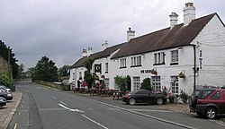
 George Hotel at Cliffe | |
| Location | |
| Grid reference: | NZ213154 |
| Location: | 54°32’3"N, 1°40’24"W |
| Data | |
| Population: | 30 |
| Post town: | Darlington |
| Postcode: | DL2 |
| Dialling code: | 01325 |
| Local Government | |
| Council: | North Yorkshire |
| Parliamentary constituency: |
Richmond (Yorks) |
Cliffe is a small village in Teesdale in the very north of the North Riding of Yorkshire, in the ancient Liberty of Richmondshire. The village stands on the south bank of the River Tees, which marks the border of County Durham. A stream called the Glen runs through the village down to the Tees.
Th village is within the Yorkshire Dales National Park. It is about six mile west of Darlington, ten miles north of Richmond and near Piercebridge.
Cliffe has a long history and prehistory, as shown by the number and range of archaeological sites from tumuli to a Civil War battleground, most of which are scheduled monuments. and the area is largely agricultural. It is notable for its 17th-century George Hotel, a Grade II listed building, where the story behind the song My Grandfather's Clock is said to have originated in 1875.
In 2015 the population of the village was estimated to be 30.
History

There is evidence of Stone Age, Iron Age, Roman and mediæval activity here, although the name "Cliffe" appears to be a mediæval name possibly referring to Cliffe Hall and its park. Cliffe has no church, but it does have its own parish, possibly owing to the previous existence of a chapel at Cliffe Hall.
This area, being close to Manfield, is part of the Gilling West Wapentake
In the early 1820s, the village was described thus:
"Cliffe, in the parish of Manfield, wapentake of Gilling West, and liberty of Richmondshire; (the seat of Henry Witham, Esq.) 1½ miles NNW. of Manfield, 6 miles WNW. of Darlington. Here is no place of worship, except a Catholic chapel, the Rev. William Hogarth, minister, Cliffe hall. Pop. 53."[1]

The Georgian mansion, Cliffe Hall, was sold in 1825 by the Withams to the Wilsons, who rebuilt it in 1859. In 1890 the 700 acres of Cliffe were the property of Colonel Wilson. The rateable value was £960, and population 72. The village was said to have derived its name from the cliffs along the river. Cliffe is again described as part of Manfield parish in 1914:
"The park of Cliffe Hall was formed in the 13th century . . . it is surrounded by plantations and traversed by a little stream, the Glen, that finds its way to the Tees. There are tumuli in the park. A lane from Cliffe crosses Watling Street and runs through Manfield to Cleasby . . . In 1717 the lord of Cliffe owned a ferry across the Tees at Manfield."[2]
The area at Cliffe Bank was affected by foot and mouth disease in 2001.[3]

About the village

The River Tees courses by the village, separating it from Piercebridge on the County Durham bank. Near the bridge stands the George Hotel, which has a clock said to be the origin of the music-hall song My Grandfather's Clock which "stopped short never to go again when the old man died".
The 1789 bridge is the local major crossing. IN Roman days there was another, the Piercebridge Roman Bridge on Dere Street, the ruin of which can be seen just east of the George.[4] This Georgian bridge is close by the old Roman road.[5]
A woodland, Kathleen Wood, grows next to Cliffe Hall, a surviving Victorian extension of a long-destroyed Georgian mansion. It is now a bed and breakfast establishment.[6]
Outside links
| ("Wikimedia Commons" has material about Cliffe, North Riding) |
- Heritage Gateway: source for North Yorkshire archaeological records.
- Yorkshire 1823 wapentakes map
- Yorkshire North Riding pre-1832 parishes map
References
- ↑ Hinson, Colin (2006). "Genuki UK & Ireland Genealogy". The Ancient Parish of Manfield. http://www.genuki.org.uk/big/eng/YKS/NRY/Manfield/index.html. Retrieved 12 January 2010.
- ↑ A History of the County of York: North Riding - Volume 1 pp 186-190: Parishes: Manfield (Victoria County History)
- ↑ "UK foot-and-mouth cases round-up 2". BBC News. 19 October 2001. http://news.bbc.co.uk/1/hi/uk/1190408.stm. Retrieved 9 January 2010.
- ↑ "Bill's Walks". Winston to Piercebridge (Teesdale Way). 25 April 2009. http://www.billswalks.co.uk/teesdale-way/winston-piercebridge-teesdale.html. Retrieved 9 January 2010.
- ↑ "Tees Archaeology". Cliffe: aerial photo of Ancient Roman road and bridge in Cliffe. 2009. Archived from the original on 16 July 2011. https://web.archive.org/web/20110716202844/http://www.teesarchaeology.com/projects/aerial_photography/gallery/index146.html. Retrieved 9 January 2010.
- ↑ Sawday, Alistair (26 February 2005). "Guardian". The best meal of the day: Cliffe Hall, Yorkshire (London). https://www.theguardian.com/travel/2005/feb/26/travelfoodanddrink.foodanddrink.hotels?page=3. Retrieved 9 January 2010.
- Muir, Richard: 'The Lost Villages of Britain (The History Press Ltd, 2008) ISBN 0-7509-5039-0, ISBN 978-0-7509-5039-8
- A History of the County of York: North Riding - Volume 1 pp 71-84: Parishes: Gilling (Victoria County History)
- A History of the County of York: North Riding - Volume 1 pp 186-190: Parishes: Manfield (Victoria County History)
