Letwell
| Letwell | |
| Yorkshire West Riding | |
|---|---|
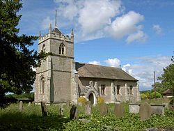
 St Peter's Church, Letwell | |
| Location | |
| Grid reference: | SK561869 |
| Location: | 53°22’37"N, 1°9’25"W |
| Data | |
| Local Government | |
| Council: | Rotherham |
Letwell is a rural village in the West Riding of Yorkshire, in the very south of the county, close to the border with Nottinghamshire. Letwell stands between Dinnington and Langold (the latter just inside Nottinghamshire), off the B6463 road. The 2011 Census recorded a population of less than 100.
The first reference to Letwell was in the 12th century when it was part of the lands of Tickhill Castle.
The parish church, St Peter's, has its 15th-century tower, and is a Grade II* listed building.[1]
The village also has two interesting dovecotes; both listed structures. One is an octagonal red-brick 18th century dovecote,[2] and the other of the late 18th century.[3]
The village of Firbeck stands to the north of Letwell, while Gildingwells is to the south.
Outside links
| ("Wikimedia Commons" has material about Letwell) |
References
- ↑ National Heritage List 1132679: Church of St Peter (Grade II* listing)
- ↑ National Heritage List 1132675: Dovecote South West of Church Rooms (Grade II listing)
- ↑ National Heritage List 1016548: Dovecote south west of South Farm (Scheduled ancient monument entry)
