Knapton, Yorkshire
| Knapton | |
| Yorkshire West Riding | |
|---|---|
 Knapton | |
| Location | |
| Grid reference: | SE561520 |
| Location: | 53°57’36"N, 1°8’42"W |
| Data | |
| Post town: | York |
| Postcode: | YO23 |
| Dialling code: | 01904 |
| Local Government | |
| Council: | York |
| Parliamentary constituency: |
York Outer] |
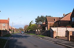
Knapton is a village in the West Riding of Yorkshire, three miles west of York. It is bounded by the village of Acomb to the east, the B1224 to the south, the A59 to the north and the A1237 York Outer Ring Road to the west.
History
There are records of a settlement here from Saxon times, but the first mention of Knapton is in the Domesday Book.[1] In 1843 the village had a population of 113 in an area of approximately 883 acres made up mainly of farmhouses. The Lord of the manor at this time was Sir William Eden.[2]
In the sixteenth century, the village was a detached part of the parish of Holy Trinity, Micklegate in York. It became a separate civil parish in 1866.[3]
Community

The current population is estimated to be 222 in approximately 96 households.
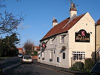
The only permanent amenity in the village is the Red Lion Public House. Local shopping, sports and religious services are served in nearby Acomb. Children of primary school age attend Poppleton Ousebank County Primary School in Upper Poppleton.[4] The Eddie Brown/Harrogate Connexions Bus route 412 from Wetherby to York calls in the village however this service is every two hours in each direction and only operates Monday to Saturday.
| ("Wikimedia Commons" has material about Knapton, Yorkshire) |
References
- ↑ "History". http://www.rufforthwithknapton-pc.gov.uk/id4.html. Retrieved 26 October 2010.
- ↑ "Lord of the Manor". https://archive.org/stream/historyandtopog00cogoog/historyandtopog00cogoog_djvu.txt. Retrieved 26 October 2010.
- ↑ "Knapton CP/Tn through time | Census tables with data for the Parish-level Unit | Vision of Britain". visionofbritain.org.uk. http://www.visionofbritain.org.uk/unit/10441821. Retrieved 28 January 2017.
- ↑ "Village Transport". http://www.york.gov.uk/content/45053/64848/64860/Planning_advice_and_guidance/Knapton_vds. Retrieved 31 October 2010.
