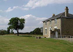
Etherdwick
From Wikishire
Revision as of 23:00, 30 June 2023 by RB (Talk | contribs) (Created page with "{{Infobox town |name=Etherdwick |county=Yorkshire |riding=East |picture=Etherdwick Grange.jpg |picture caption=Etherdwick Grange |os grid ref=TA232372 |latitude=53.816568 |lon...")
| Etherdwick | |
| Yorkshire East Riding | |
|---|---|
 Etherdwick Grange | |
| Location | |
| Grid reference: | TA232372 |
| Location: | 53°48’60"N, 0°7’46"W |
| Data | |
| Post town: | Hull |
| Postcode: | HU11 |
| Dialling code: | 01964 |
| Local Government | |
| Council: | East Riding of Yorkshire |
| Parliamentary constituency: |
Beverley and Holderness |
Etherdwick is a hamlet in the East Riding of Yorkshire, on Holderness in the south-east of the riding.
This hamlet is about nine miles north-west of Withernsea town centre, and a mile and a half west of the B1242 road.
In 1823 Bulmer's Topography, History and Directory of East Yorkshire wrote Etherdwick's name as "Etherdwicke". Recorded in the hamlet were three farmers.[1]
Outside links
| ("Wikimedia Commons" has material about Etherdwick) |
- Etherdwick in the Domesday Book
References
- ↑ Baines, Edward: 'History, Directory and Gazetteer of the County of York' (1823); pages 202, 203
- Gazetteer — A–Z of Towns Villages and Hamlets. East Riding of Yorkshire Council. 2006. p. 5.