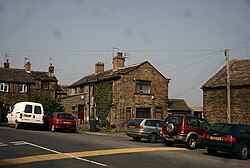
Clayton, Bradford
| Clayton | |
| Yorkshire West Riding | |
|---|---|
 Town End Clayton | |
| Location | |
| Grid reference: | SE123317 |
| Location: | 53°46’55"N, 1°48’48"W |
| Data | |
| Population: | 16,982 (2011) |
| Post town: | Bradford |
| Postcode: | BD14 |
| Dialling code: | 01274 |
| Local Government | |
| Council: | Bradford |
| Parliamentary constituency: |
Bradford West |
| Website: | clayton-village.co.uk |
Clayton, or 'Clayton Village', is a village in the West Riding of Yorkshire, three miles west of Bradford city centre.
It is listed in the Domesday Book, meaning it dates back to at least the 11th century and was privately owned from 1160 to 1866.[1] It was noted for its clay. More recently, Clayton was a key location in the British and international wool trade, being the home of the British Wool Marketing Board headquarters. The old building was demolished and converted into housing in the late 1990s.
The main street of the village – Clayton Lane – which runs alongside the park, includes several traditional pubs, a popular crawl route for many residents. Starting at the top of the lane is the Fleece, moving down past the Royal Hotel to the Albion and the Black Bull – the oldest pub in the area.The Fiddlers Three and the Quarry Arms have now shut down. There are also several shops, churches and a nearby golf club and reservoir at Clayton Heights (now designated as a Country Park) with views of the city of Bradford and the village of Thornton across the valley.
History

Evidence of presence of prehistoric people in Clayton was found in 1951 when a Neolithic stone axe was found in Thornlea Grove, the axe is now in the Cartwright Hall Museum.
Clayton is listed in the Domesday Book in 1086 as the Manor Claitone, and held by Ilbert de Lacy. The name of the village is probably exactly as it seems, deriving from clæg meaning 'clay' and so 'farmstead on clay'.[2] The village was privately owned from 1160 to 1866 when a local board was formed to manage the village. During the 1870s "the wells", on the central village roundabout, was used as a site for open air preaching.
Clayton was a township in the ancient parish of Bradford.[3]
The now-defunct Clayton Tide newspaper described the central role of the pubs in Clayton village life in a 15 August 1861 account of a visit to the village by Pablo Fanque, the popular Victorian circus owner who The Beatles later immortalised in the song Being for the Benefit of Mr. Kite! The Clayton Tide reported, "On Sunday, a great number of persons visited the village, but ignoring the "Teetotal Lectures" which were given at Town Bottom, the public houses were well attended. Mr Pablo Fanque, always welcome on such occasions, was present and a damsel in his company, who emulated Blondin's feats, drew a large crowd."
Geography

Clayton stands at about 720 feet above sea level at the south end of a relatively flat ridge of land on the south side of Clayton Beck valley. The valley drops steeply below this shoulder of land and rises steeply to the south, south-east and south-west.[4] The soil is mainly of a clay character but there are deposits of sandstone and gritstone.[2]
The village is three miles from Bradford city centre, with the village of Thornton located on the other side of the valley and the village of Queensbury further up the hill that Clayton is situated on. Clayton Beck runs through the bottom of the valley below Clayton and tributaries for this stream, including Bull Grieve Beck, run through the village.
The centre of the village is designated as a conservation area in 1977.[5]
The main street of the village – Clayton Lane – which runs alongside the park, includes several traditional pubs, a popular crawl route for many residents. Starting at the top of the lane is the Fleece, moving down past the Royal Hotel to the Albion and the Black Bull – the oldest pub in the area.
Churches

- Church of England: St John The Baptist, completed in 1851
- Baptist: Clayton Baptist Church
- Independent / evangelical: Clayton Gospel Hall, on Bradford Road
- Methodist
- Roman Catholic: St Anthony's
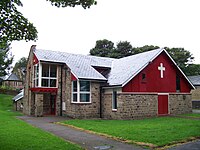
St John The Baptist was finished in 1851.[6] A new 'Community Rooms' extension was opened in 2011 to provide additional space for church activities, art classes, community choir, Scouts and more.
Clayton Gospel Hall was opened in 1928. In 1978, the Gospel Hall was bolstered by a formerly Brethren congregation that began in Girlington but had lost tenancy of Kensington Hall.[7] The Baptist Church on School Street opened for worship in 1984, replacing the previous Baptist Church building that dated from 1891 but had to be demolished due to dry rot.[8]
Sport
- Cricket:
- Clayton Cricket Club
- Mayfield Cricket Club
- Football: Clayton Albion F.C. who run from the Black Bull Inn
- Golf: Clayton Golf Club, at Thornton View Road, founded in 1906
- Rugby League: Clayton RLFC, who play on Lidget Green Cricket Club
Outside links
| ("Wikimedia Commons" has material about Clayton, Bradford) |
References
- ↑ Dalgety, Margaret; Downey, Stuart (2005). Images of Clayton. Stroud: Tempus Publishing Limited. p. 7. ISBN 9780752437019.
- ↑ 2.0 2.1 "Clayton: Conservation Area Assessment". City of Bradford Metropolitan District Council. February 2006. p. 8. http://www.bradford.gov.uk/NR/rdonlyres/35F3D3BF-0C5C-48ED-8875-84D41204EC9F/0/ClaytonConservationAreaAssessmentFinal.pdf.
- ↑ "History of Clayton, in Bradford and West Riding - Map and description". http://www.visionofbritain.org.uk/place/848.
- ↑ "Clayton: Conservation Area Assessment". City of Bradford Metropolitan District Council. February 2006. p. 15. http://www.bradford.gov.uk/NR/rdonlyres/35F3D3BF-0C5C-48ED-8875-84D41204EC9F/0/ClaytonConservationAreaAssessmentFinal.pdf.
- ↑ "Clayton conservation area assessment". Bradford Council. February 2006. p. 6. http://www.bradford.gov.uk/NR/rdonlyres/35F3D3BF-0C5C-48ED-8875-84D41204EC9F/0/ClaytonConservationAreaAssessment.pdf.
- ↑ Dalgety, Margaret; Downey, Stuart (2005). Images of Clayton. Stroud: Tempus Publishing Limited. pp. 96–97. ISBN 9780752437019.
- ↑ Rushton, Christopher (2008) |The Complete History of Clayton Gospel Hall
- ↑ Dalgety, Margaret; Downey, Stuart (2005). Images of Clayton. Stroud: Tempus Publishing Limited. pp. 110–113. ISBN 9780752437019.
