Agglethorpe
| Agglethorpe | |
| Yorkshire North Riding | |
|---|---|
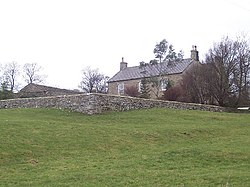
 Farm at Agglethorpe | |
| Location | |
| Grid reference: | SE086864 |
| Location: | 54°16’26"N, 1°52’5"W |
| Data | |
| Post town: | Leyburn |
| Postcode: | DL8 |
| Local Government | |
| Council: | Richmondshire |
Agglethorpe is a hamlet in the North Riding of Yorkshire, in the northern reaches of Coverdale, some four miles south-west of Leyburn.
History
In 1086 the village was recorded as Aculestorp in the Domesday Book.[1]
In 1870–72 John Marius Wilson's Imperial Gazetteer of England and Wales described Agglethorpe as:
"A joint township with Coverham, in Coverham parish, W. R. Yorkshire".[2]
Agglethorpe Hall (a Grade II listed building) was built in the 17th century.[3]
Outside links
| ("Wikimedia Commons" has material about Agglethorpe) |
- Agglethorpe in the Domesday Book
References
- ↑ Agglethorpe in the Domesday Book
- ↑ Wilson, John (1870–72). Imperial Gazetteer of England and Wales. Edinburgh: A. Fullarton and Co.. http://visionofbritain.org.uk/place/place_page.jsp?p_id=11093#. Retrieved 4 February 2013.
- ↑ National Heritage List 1130887: Agglethorpe Hall (Grade II listing)
