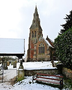
Stratfield Mortimer
| Stratfield Mortimer | |
| Berkshire | |
|---|---|
 St. Mary's Church | |
| Location | |
| Grid reference: | SU6664 |
| Location: | 51°22’23"N, 1°2’13"W |
| Data | |
| Population: | 3,807 (2011) |
| Post town: | Reading |
| Postcode: | RG7 |
| Dialling code: | 0118 |
| Local Government | |
| Council: | West Berkshire |
Stratfield Mortimer is a village just south of Reading in Berkshire.
This is a linear village which climbs Mortimer Hill rising westward from the Foudry Brook. It becomes scattered and has no fixed formal or historic boundaries with Mortimer Common.
Geography
The south and south-east half of the parish consists of farms with a small percentage of woodland and is bisected towards the middle of the whole area by the Foudry Brook and adjacent Reading to Basingstoke railway line which is more than 40% on raised embankments but in the far south is in a cutting. The northeast of the parish is the most populated, at Mortimer Common, which is commonly just known as Mortimer, and here are found the shops and retail outlets of the parish: Mortimer Common is at the top of the hill.
Mortimer Woods are in the northwest of the parish, and the woods and common land blend into Wokefield Common. Mortimer Woods has a set of Scheduled Ancient Monuments – one large, steep Bronze Age round barrow and three further smaller bowl barrows.[1]
South of the village is the border with Hampshire. Close by is a long, straight footpath which is known as the Devil's Highway; this is the eastern part of the Roman road from London to Bath, which is marked out today from Bagshot in Surrey to the remarkable site of Calleva Atrebatum by Silchester, two miles southwest of Stratfield Mortimer in Hampshire.
About the village
The village has a parish church, St Mary's, a restaurant, a junior school (Mortimer St Mary's Junior School), and the headquarters of the Berkshire Federation of Women's Institutes is here too.
The Foudry Brook is crossed by a scenic Victorian bridge with footways known as Tun Bridge. The Lockram Brook flows through the middle of the parish.
Sports
- Mortimer Tennis Club
- Mortimer Cricket Club
- Mortimer Football Club
The local golf club is at Wokefield Park
Mortimer West End
The ancient parish of Stratfield Mortimer extends into Hampshire, with that part known as Mortimer West End. Mortimer West End became an ecclesiastical parish in its own right in 1870 (and a civil parish in 1894).[2]
However, the Stratfield Mortimer ecclesiastical parish today continues to include a small uninhabited fraction of Mortimer West End.[3]
Outside links
| ("Wikimedia Commons" has material about Stratfield Mortimer) |
References
- ↑ National Heritage List 1012304: Stratfield Mortimer, National Heritage List 1012425: Stratfield Mortimer,National Heritage List 1012427: Stratfield Mortimer,National Heritage List 1012804: Stratfield Mortimer
- ↑ A History of Hampshire Vol 4 pages 55-56 (1911), Victoria County History
- ↑ Parish of Stratfield Mortimer (Churches of St John the Evangelist and St Mary) Retrieved 2014-12-10.