Littleton, Surrey
| Littleton | |
| Surrey | |
|---|---|
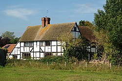
 Orange Court Farm, Littleton | |
| Location | |
| Grid reference: | SU981473 |
| Location: | 51°12’60"N, -0°35’45"W |
| Data | |
| Postcode: | GU3 |
| Local Government | |
| Council: | Guildford |
Littleton is a hamlet in the south-west of Surrey, sitting between Guildford to the north and Godalming to the south, strung along Littleton Lane. It is at the foot of the southern slope of the Hog's Back.
The hamlet consists of Loseley House, Orange Court, Orange Court Farm, and a few cottages. Due to the ruin of St Catherine's Chapel in St Catherine's Hill and like the rest of Artington civil parish, it falls within the ecclesiastical parish of St Nicholas, Guildford.[1]
At the time of the Domesday Book Littleton was held by Wulwi or Wulfwi, a huntsman, who it records held it before the Norman Conquest, had two households described as a villager and a cottager and the place only rendered £1 from its assets including a ploughland for two plough teams and two acres of meadow.[2]
To the west of the hamlet are Loseley Park and Loseley House: the house a fine Elizabethan stately home built in 1562 by Sir William More (a direct ancestor of the current owner) at the request of Queen Elizabeth I.
Outside links
| ("Wikimedia Commons" has material about Littleton, Surrey) |
References
- ↑ Guildford, St Nicholas: A Church Near You
- ↑ Littleton, Surrey in the Domesday Book
