Golders Green
| Golders Green | |
| Middlesex | |
|---|---|
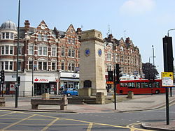
 Golders Green clock tower | |
| Location | |
| Grid reference: | TQ248876 |
| Location: | 51°34’24"N, 0°11’54"W |
| Data | |
| Population: | 18,818 (2011) |
| Post town: | London |
| Postcode: | NW11, NW2 |
| Dialling code: | 020 |
| Local Government | |
| Council: | Barnet |
| Parliamentary constituency: |
Finchley & Golders Green / Hendon |
Golders Green is a suburban town area in Middlesex within the metropolitan conurbation. It began as a smaller, linear settlement, near a farm and public grazing area green of mediæval origins, but its form today is from the early 19th century. Its bulk forms a late 19th-century and early 20th-century suburb with a commercial crossroads. The rest is of later build. It is centred on the intersection of Golders Green Road and Finchley Road.
Founded as a mediæval hamlet in the large parish of Hendon, Golder’s Green grew rapidly in response to the opening of Golders Green tube station on the London Underground, adjacent to the Golders Green Hippodrome (which was home to the BBC Concert Orchestra for many years). The area has a wide variety of housing and a busy main shopping street, Golders Green Road.
It is known for its large Jewish population as well as for being home to the largest Jewish kosher hub (located west of Hoop Lane after the rail bridge) in the United Kingdom, which attracts many Jewish tourists.

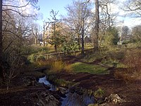
Golders Hill Park, adjoining the West Heath of Hampstead Heath, is a formal park, which includes a small zoo, a walled horticultural garden, pinetum, duckponds, a water garden and a café. During the summer, children's activities are organised and there is often live music on the bandstand. Close to the park, also adjoining the West Heath is the Hill, a formal garden with an extensive and imposing pergola.
History
The name Golders comes from a family named Godyere who lived in the area, and Green alludes to the manorial common at a crossroads next to which the settlement was built.[1] Golders Green has been a place in the parish and manor of Hendon since around the 13th century. The earliest references to the name of the adjacent district of "Temple Fortune" is on a map (c. 1754). However this name reveals a much earlier history. It is likely that the name refers to the Knights of St John, who had land here (c. 1240). Fortune may be derived from a small settlement on the route from Hampstead to Hendon. Here a lane from Finchley, called Ducksetters Lane (c. 1475), intersected. It is likely that the settlement was originally the Bleccanham estate (c. 10th century). By the end of the 18th century Temple Fortune Farm was established on the northern side of Farm Close.
The building of Finchley Road (c. 1827) replaced Ducksetters Lane as a route to Finchley, and resulted in the development of a small hamlet. Hendon Park Row (c. 1860s) is of this period, and consisted of around thirty small dwellings built by a George Stevens, which were, with two exceptions, demolished around 1956. A small dame school and prayer house run by Anglican deaconesses existed in the 1890s and 1900s, and developed to become St. Barnabas (1915). Along Finchley Road were a number of villas (c. 1830s), joined by the Royal Oak public house (c. 1850s). By the end of the 19th century there were around 300 people living in the area, which included a laundry and a small hospital for children with skin diseases. The principal industry was brick making.
In 1895 a Jewish cemetery was established adjacent to Hoop Lane, with the first burial in 1897. Golders Green Crematorium was opened in 1902 (although much of it was built after 1905). A significant moment in Temple Fortune's development into a suburban area occurred in 1907, when transport links were vastly improved by the opening of Golders Green Underground station.
Although the area had been served by horse-drawn omnibuses (since at least the 1880s) and later motor buses (from 1907), the tram line of 1910, connecting Finchley Church End with Golders Green Station, led to the development of the area west of Finchley Road. The establishment of Hampstead Garden Suburb brought major changes to the area east of Finchley Road. Temple Fortune Farm was demolished and along the front of the road the building of the Arcade and Gateway House (c. 1911) established the Hampstead Garden Suburb's retail district.
Both the Golders Green Hippodrome, former home of the BBC Concert Orchestra, and the police station opened in 1913.[2] The now-demolished Orpheum Theatre (1930) was intended to rival the Hippodrome in Golders Green.
Society
Jewish community
There has been a prominent Jewish community in Golders Green since the early 20th century. The Jewish community took root after Hitler's rise to power in German, with the first German Jewish immigrants forming the Golders Green Beth Hamedrash. Soon after, Galician Jewish immigrants formed other synagogues. With it came the formation of Jewish schools such as Menorah before the onset of the Second World War.
There are close to fifty Kosher restaurants and eateries under rabbinical supervision in Golders Green, and more than 40 synagogues dotted throughout the area continuing into neighbouring Hendon, as well as 30 schools (some in outlying areas due to space restriction), many of them private
The Jewish community of Hendon and Golders Green is viewed as one, sharing the schooling system as well as rabbinical guidance.
Japanese and East Asian community
Golders Green is home to a growing Japanese and East Asian community[3] with many families living in the district[4] being catered for a notable number of restaurants and shops specialising in Japanese and other East Asian food, such as the Seoul Plaza supermarket.
Churches and synagogues


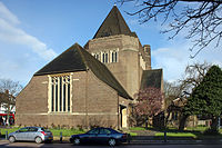
- Church of England: Church of St Alban the Martyr, in North End Road, designed by Sir Giles Gilbert Scott and built in 1933 replacing the original eponymous church (which is now the parish hall) built in 1910.[5]
- Eastern Orthodox:
- Both were Anglican churches for most of the 20th century. The Greek orthodox church was built in 1914.
- Roman Catholic: St. Edward the Confessor, built in 1915 and consecrated in 1931.[8]
- Unitarian Church, built in 1925 on Hoop Lane[9]
- Synagogues:
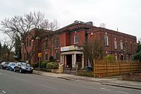
- Golders Green Synagogue, started in 1915 and its current building in Dunstan Road opened in 1922.[10][11]
- Beth Hamedrash opened in Golders Green in 1935, moving to the Riding in 1956
- Sassover Beis Hamedrash on Helenslea Avenue
- Beis Yissochor Dov, in Highfield Avenue
- Beth Shmuel opened in 1942 in Oakfields Road and relocated at 169–171 Golders Green Road since 1952[12] and is one of the most prominent synagogues in North West London with Grand Rabbi Elchonon Halpern its longest serving Rabbi.
- Ohel David Eastern Synagogue, at the Lincoln Institute, the former site of the Golders Green Beth Hamedrash.[13]
- Machzike Hadath Synagogue which moved to Golders Green in the 1970s
| ("Wikimedia Commons" has material about Golders Green) |
References
- ↑ Weinreb, Ben (2008). The London Encyclopaedia (3rd ed.). pp. 328–329. ISBN 978-1-4050-4924-5.
- ↑ "The UK's best military driving gifts". wanadoo-members.co.uk. Archived from the original on 10 November 2005. https://web.archive.org/web/20051110212827/http://mysite.wanadoo-members.co.uk/stedwardgg/index.html.
- ↑ "Golders Green – Hidden London". http://hidden-london.com/gazetteer/golders-green/. Retrieved 26 October 2017.
- ↑ Kosher in the country The Economist 1 June 2006 accessed 14 August 2007
- ↑ AIM25 Retrieved 29 November 2013
- ↑ The Greek Orthodox Retrieved 1 May 2012
- ↑ St. Mary & Archangel Michael Coptic Orthodox Church Golders Green, U.K. Retrieved 1 May 2012
- ↑ "Roman Catholic Church of St Edward the Confessor". rcdow.org.uk. http://www.rcdow.org.uk/goldersgreen/parishinfo/default.asp.
- ↑ National Heritage List 1390934: Unitarian Chapel
- ↑ "Golders Green Synagogue". Golders Green Synagogue. http://www.goldersgreenshul.org.uk/.
- ↑ "Helen Fry » Golders Green Synagogue: The First 100 Years". Helen Fry. http://www.helen-fry.com/anglo-jewish-history/golders-green-synagogue-the-first-100-years/.
- ↑ [1]
- ↑ Jewish Communities & Records 14 December 2011 Retrieved 1 May 2012
