Clay Hill
| Clay Hill | |
| Middlesex | |
|---|---|
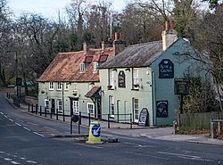
 The "Rose and Crown", Clay Hill | |
| Location | |
| Grid reference: | TQ325988 |
| Location: | 51°40’21"N, 0°5’3"W |
| Data | |
| Post town: | Enfield |
| Postcode: | EN2 |
| Dialling code: | 020 |
| Local Government | |
| Council: | Enfield |
| Parliamentary constituency: |
Enfield North |
Clay Hill is a semi-urban village in north-eastern Middlesex, to the north of Enfield. It is mainly a residential area which almost borders Crews Hill to the north and forms part of the Metropolitan Green Belt.
Places of interest include Clay Hill House, Whitewebbs Park, Hillyfields Park and Forty Hall. The North Enfield Cricket Club ground is located within the Clay Hill area, at the top of Hilly Fields Park.
Clay Hill is recorded as Clayhyll (1524), Clayhillgate (1636); apparently self-explanatory, in which the suffix gate refers to gate of Enfield Chase. However, the local name Claysmore, earlier Clayes More Grove (1610), is associated with the family of William atte Cleye (that is 'at the clayey place') (1274), John Clay (1420). Clay Hill may derive from a surname rather than the word clay.[1]
History
Whitewebbs has links with the Gunpowder Plot, as Guy Fawkes and his fellow conspirators are known to have used a safe house in Whitewebbs Lane, Enfield. The claim as to location of this safe house is held by the Rose and Crown public house, which was extended into what would have been cottages at the time. Fawkes met with Robert Catesby at the original Whitewebbs House which was located on the site of what is now Guy's Lodge Farm opposite the King and Tinker public house.[2]
Outside links
References
- ↑ Mills A. D. Oxford Dictionary of London Place Names (2001) p49 ISBN 0-19-860957-4 Retrieved 27 October 2008
- ↑ Gunpowder Plot Retrieved 14 March 2015