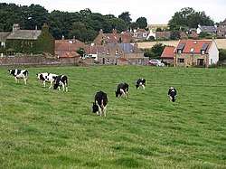
Boarhills
| Boarhills | |
| Fife | |
|---|---|
 Boarhills | |
| Location | |
| Grid reference: | NO564140 |
| Location: | 56°18’59"N, 2°42’17"W |
| Data | |
| Population: | 80 (2001) |
| Post town: | St Andrews |
| Postcode: | KY16 |
| Dialling code: | 01334 |
| Local Government | |
| Council: | Fife |
| Parliamentary constituency: |
North East Fife |
Boarhills is a hamlet close to Kingsbarns on the East Neuk of Fife. It is located off the A917 road, 4½ miles from St Andrews and 5½ miles from Crail, close to the mouth of Kenly Water with the North Sea.
History
Boarhills Church, built in 1866–67, stands apart from the village, with a large bellcote at its western end. Boarhills had a primary school, built in 1815 and which closed in the 1990s.[1]
Boarhills had a railway station on the North British Railway line from Thornton Junction to St Andrews via Crail.[2] The station closed to passengers on 22 September 1930 and to goods on 5 October 1964. The line was closed completely on 6 September 1965. This station was sited to the south of the A917.[3]
Buddo Rock is a sandstone sea stack on a raised beach close to Boarhills, 900 yards from Buddo Ness, accessible by the Fife Coastal Path. Nearby is a former lifeboat station, built between 1860 and 1890.
| ("Wikimedia Commons" has material about Boarhills) |
References
- ↑ "Boarhills". Undiscovered Scotland. http://www.undiscoveredscotland.co.uk/kingsbarns/boarhills/index.html. Retrieved 24 June 2011.
- ↑ "Anstruther and St Andrews Railway". RailScot. 23 February 2006. http://www.railbrit.co.uk/Anstruther_and_St_Andrews_Railway/frame.htm. Retrieved 24 June 2011.
- ↑ "NO5613 : Site of Boarhills Station". Geograph Britain and Ireland. https://www.geograph.org.uk/photo/1838499. Retrieved 24 June 2011.
