Kildorrery
| Kildorrery Irish: Cill Dairbhre | |
| County Cork | |
|---|---|
 Kildorrery | |
| Location | |
| Grid reference: | R709105 |
| Location: | 52°14’46"N, 8°25’37"W |
| Data | |
| Population: | 357 (2016) |
| Local Government | |
| Dáil constituency: |
Cork East |
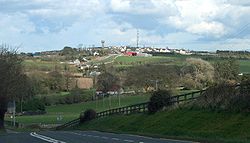
Kildorrery is a village in the Barony of Fermoy in northern County Cork, at the crossroads of the N73 road from Mallow to Mitchelstown and the R512 from Kilmallock to Fermoy.
The name of the place is the Irish Cill Dairbhre; 'Oak-forest church.[1]
This hilltop village has views to the east of the Galtee Mountains and Knockmealdown Mountains with Slievenamon in the distance. To the north the Ballyhouras – the Limerick road is flanked by two mountains, Castlegale and Carrigeenamronety (Carraigín na mBróinte). To the south, across the Blackwater Valley are the Nagle mountains, and to the west towards County Kerry the Paps are sometimes visible.
The village hosts an annual food fair in which local families (of various nationalities) allow people to sample the cuisine of their native countries.
Economy
The local economy is based on agriculture. There is a large horticultural business, a national haulage firm and several small family run pubs and shops.
References
- ↑ Dairbhre Kildorrery: Placenames Database of Ireland