Bramley Vale
| Bramley Vale | |
| Derbyshire | |
|---|---|
 Bramley Vale | |
| Location | |
| Grid reference: | SK465662 |
| Location: | 53°11’28"N, 1°18’20"W |
| Data | |
| Post town: | Chesterfield |
| Postcode: | S44 |
| Dialling code: | 01246 |
| Local Government | |
| Council: | Bolsover |
| Parliamentary constituency: |
Bolsover |
Bramley Vale is a former coal-mining village in the north-east of Derbyshire, south of Bolsover. It is in the civil parish of Ault Hucknall.
The village is found four miles south of Bolsover, close to junction 29 of the M1 motorway. The A617 road runs through the village.
History
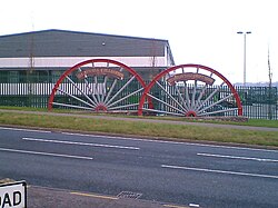
As a colliery village, Bramley Vale has a lengthy mining heritage, beginning with the opening of the Glapwell colliery in 1882. It closed in 1974 with all the men being transferred to other local collieries.[1]
Outside links
| ("Wikimedia Commons" has material about Bramley Vale) |
References
- ↑ Bramley Vale Drifts: OldMiner.co.uk]

This Derbyshire article is a stub: help to improve Wikishire by building it up.
