Manorowen
| Manorowen | |
| Pembrokeshire | |
|---|---|
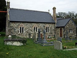
 South aspect of St Mary's Church | |
| Location | |
| Grid reference: | SM9336 |
| Location: | 51°58’48"N, 5°-0’36"W |
| Data | |
| Post town: | Fishguard |
| Postcode: | SA65 |
| Local Government | |
| Council: | Pembrokeshire |
| Parliamentary constituency: |
Preseli Pembrokeshire |
Manorowen is a small settlement and ancient parish in the Dewisland Hundred of Pembrokeshire, on the A487 road, two miles south-west of Fishguard. The parish includes the village of Scleddau—the eastern part of which is in the neighbouring parish of Llanstinan. A listed property bears the name of the parish, and the church is dedicated to St Mary.
History
The origin of the parish name is obscure because there have been many different spellings throughout history, including Maenor Owain, Manerowen, Manorawen and Manernawen, but the earliest recorded document is dated 1453.[1] It is marked as Manerowen on a 1583 parish map of Pembrokeshire.[2]
In 1688 John Lewis Esquire of Manernawen (sic) was appointed Commissioner for Haverfordwest under an act to collect money for a royal grant.[3]
The parish church of St Mary is 19th century with later additions, but contains a memorial dated about 1670; the oldest gravestone is about 1791.[4][5] The church was closed for a time following a bat infestation, but remedial work resulted in its reopening in 2015.[6]

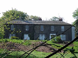
Manorowen is the name of an estate, whose house, walled garden and gazebo are Grade-II listed.[7] The present house dates from about 1830.[5][8][9] According to the charity Parks and Gardens, the site was first created between 1650 and 1699,[10] and was recorded by Richard Fenton as belonging to his great grandfather John Lewis (see above) in the late 17th century when it was called Manarnawen.[8]
Lewis's 1833 Topographical Dictionary of Wales notes Manorowen (or Maenor-Owain) as being a small parish[11] in the Hundred of Dewisland, with 220 inhabitants.[12]
From 1913 until 2004, there was a school at Manorowen. The school's log books, admission register, photographs and miscellaneous papers are held at the Pembrokeshire Archives.[13]
Notable people
David Jones, vicar of Llangan and an early supporter of Welsh Calvinistic Methodism, lived in Manorowen and Richard Fenton (1747-1821) is buried there.
References
- ↑ "British History Online: Parliament Rolls: Henry VI". http://www.british-history.ac.uk/no-series/parliament-rolls-medieval/march-1453. Retrieved 27 February 2018.
- ↑ "Penbrok comitat". British Library. https://www.bl.uk/onlinegallery/onlineex/unvbrit/p/zoomify83390.html.
- ↑ "British History Online:William and Mary, 1688: An Act...". http://www.british-history.ac.uk/statutes-realm/vol6/pp104-142#highlight-first. Retrieved 27 February 2018.
- ↑ "Coflein: St Mary's Church, Manorowen". http://www.coflein.gov.uk/en/site/403329/details/st-marys-church-manorowen. Retrieved 28 February 2018.
- ↑ 5.0 5.1 Lloyd, T., Orbach, J., Scourfield,R. (2004). "Pembrokeshire". Yale University Press. pp. 279–280. https://books.google.com/books?id=AyK4f2_8H78C&dq=Manorowen. Retrieved 28 February 2018.
- ↑ "Open for worship". Pobl Dewi. St Davids Diocese. 1 June 2016. p. 9. http://s3.amazonaws.com/cinw/wp-content/uploads/sites/4/2016/06/PoblDewiJune2016.pdf. Retrieved 28 February 2018.
- ↑ "British Listed Buildings: Manorowen". https://www.britishlistedbuildings.co.uk/search/?q=Manorowen#.WpWBkCOLQl5. Retrieved 27 February 2018.
- ↑ 8.0 8.1 "Coflein: Manorowen". http://orapweb.rcahms.gov.uk/coflein//C/CPG176.pdf. Retrieved 27 February 2018.
- ↑ Cadw Manorowen (Grade II) (13029) Retrieved 12 August 2019.
- ↑ "Parks and Gardens: Manorowen". http://www.parksandgardens.org/places-and-people/site/2221. Retrieved 27 February 2018.
- ↑ "GENUKI: Manorowen Parish Map". https://www.genuki.org.uk/big/wal/PEM/Newport/ParishMap. Retrieved 26 February 2018.
- ↑ "GENUKI: Manorowen". https://www.genuki.org.uk/big/wal/PEM/Manorowen. Retrieved 26 February 2018.
- ↑ "National Archives: Manorowen School". http://discovery.nationalarchives.gov.uk/details/c/F195388. Retrieved 27 February 2018.
Outside links
| ("Wikimedia Commons" has material about Manorowen) |
