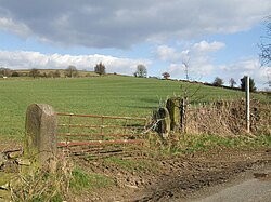
Ashleyhay
| Ashley Hay | |
| Derbyshire | |
|---|---|
 Ashley Hay, looking towards Spout. | |
| Location | |
| Grid reference: | SK291517 |
| Location: | 53°3’43"N, 1°33’58"W |
| Data | |
| Population: | 118 (2011) |
| Post town: | Matlock |
| Postcode: | DE4 |
| Local Government | |
| Council: | Amber Valley |
Ashleyhay is a village in eastern Derbyshire, about five miles north-west of Belper and just one and three-quarters of a mile south of Wirksworth. It is eleven miles north of the city centre of the county town, Derby city centre. The 2011 census recorded the population of Ashleyhay to be 118.
The name of the village is believed to be from the Old English æsc leah hæg, interpreted as 'Ash-tree meadow (or clearing) enclosure (or hedge)'.[1]
History
In 1823, Samuel Lewis wrote of Ashelyhay township as included within Wirksworth Parish:[2]
There is also a manor within the parish, which has no courts, called the Holland, or Richmond, manor, granted in 1553, by the crown, to Ralph Gell. The parish comprises 14,022a. 3r. 20p., and includes the chapelries of Alderwasley and Cromford; the townships of Ashley-Hay, Biggin, Hopton, Ible, and Idridgehay with Allton; and the hamlets of Callow, Ivonbrook-Grange, and Middleton.
In 1870–72 John Marius Wilson described Ashleyhay as:
"a township in Wirksworth parish, Derby; 1 mile SE of Wirksworth. Pop., 232. Houses, 49."[3]
About the village

Alport Height
On the southern edge of Ashleyhay parish is a hill called the Alport Height, at its summit this area of high ground is 1,000 feet above sea level. In 1930 nine acres of land were acquired on the hill by the National Trust: the first piece of land they acquired in Derbyshire of scenic nature, it has remained free admission to the site since they acquired it.
Visible on the side of the Alport Height hill is an old quarry. A conspicuous pillar of quarried gritstone, some 20 feet tall stands near the summit of the hill.[4]
Ecclesbourne Valley Railway
The Ecclesbourne Valley Railway runs through the west side of Ashleyhay on its path from Wirksworth to Duffield.[5] Now a heritage railway mainly for the use of tourists it started off life in 1867 as both a passenger and freight route, the passenger trains were stopped in 1947 and the freight trains ceased operation in 1964, the whole line was closed in 1989. In 2000 a group of volunteers started work clearing the railway of vegetation, by 2002 the railway had reopened it passenger services on parts of the line. The line now is fully operational and is the longest heritage railway in Derbyshire. Train timetables on the line now coincide with the mainline railway service at Duffield meaning it is possible to commute anywhere on the national network from the Eccelsbourne Valley Railway.
References
- ↑ Key to English Place-names: The English Place Name Society
- ↑ Lewis, Samuel: 'A Topographical Dictionary of England' (S. Lewis and Co., 1848) pp622–625 ISBN 978-0-8063-1508-9
- ↑ Wilson, John Marius: Imperial Gazetteer of England and Wales (A. Fullerton & Co., 1870)
- ↑ "Ashleyhay – Alport Heights". 1 August 2010. http://www.ilkcam.com/Archived/2010/0801Alport.html.
- ↑ Eccelsbourne Valley Railway