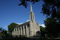
Whitechurch, County Dublin
| Whitechurch Irish: An Teampall Geal | |
| County Dublin | |
|---|---|
 Whitechurch (Church of Ireland) church | |
| Location | |
| Grid reference: | O141266 |
| Location: | 53°16’41"N, 6°17’22"W |
| Data | |
| Local Government | |
| Council: | South Dublin |
Whitechurch is a suburbanised village on the south side of Dublin, sitting to the south of Ballyboden in Rathfarnham at the foot of the Dublin mountains. It derives its name from a small white church in Kilmashogue, built near an ancient cairn (which is a protected monument). Little remains of the church.
The Church of Ireland parish of Whitechurch includes most of Rathfarnham including Tibradden, Larch Hill and Kilmashogue.
There is a Moravian cemetery in the area which was the burial ground for the Moravian community, a Protestant group originating in Bohemia and Moravia, from the Hussite reformation, who arrived in Ireland in the 18th century. This community had a church in Kevin Street but have now died out.
The Roman Catholic order Augustinian Fathers have been in the area for many years.