Rathfarnham
| Rathfarnham Irish: Ráth Fearnáin | |
| County Dublin | |
|---|---|
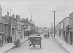
 Main Street in Rathfarnham, circa 1905 | |
| Location | |
| Grid reference: | O144289 |
| Location: | 53°17’56"N, 6°17’8"W |
| Data | |
| Population: | 17,333 (2006) |
| Post town: | Dublin |
| Postcode: | D14, D16 |
| Dialling code: | 01 |
| Local Government | |
| Council: | South Dublin Dún Laoghaire–Rathdown |
| Website: | www.rathfarnham.com |
Rathfarnham is a village to the south of Dublin city centre and which has become a suburb within the cityscape. It is south of Terenure, east of Templeogue.
The name of the village is from the Irish Ráth Fearnáin, meaning 'Fearnán's ringfort'.
History
Early and mediæval history
The name 'Fearnain's Ringfort' suggests an earlier habitation, but no remains of prehistoric fortifications, burial places, early churches or old records have been found.
The written history of Rathfarnham begins after the Norman invasion of Ireland. Terenurr and Kimmage (Cheming), both described as being in Rathfranham (sic) parish Dublin, are mentioned in an 1175 grant by Henry II to Walter the goldsmith ('Aurifaber') held at Canterbury Cathedral Archives.[1]
In 1199 these lands were granted to Milo le Bret. In 1199 he adapted an existing ridge to build a motte and bailey fort at what is now the start of the Braemor Road. It was apparently still in evidence up to the early 20th century.
In the following century no events of great importance are recorded as Rathfarnham, perhaps as it was protected on its south side by the Royal Forest of Glencree. Rathfarnham became more exposed to attack when this deer park was overrun by the Clan O'Toole from the Wicklow Mountains in the 14th century. Rathfarnham Castle was erected in part to protect the area from such attacks.

In addition, part of the Pale's defences ran through the townland of Rathfarnham. Some traces of this are still extant.
From the 16th century
The castle and much of the land around Rathfarnham belonged to the Eustace family of Baltinglass. However, their property was confiscated for their part in the Second Desmond Rebellion of 1579-1583. The castle and its lands were then granted to the Loftus family.
In the 1640s, the Loftus family was at the centre of the Irish Confederate Wars arising out of the Irish Rebellion of 1641. In 1649, the castle was seized by the Earl of Ormonde's Catholic and Royalist forces before the battle of Rathmines. However they were granted it back by the English parliamentarians after their victory in that battle. Reputedly, Oliver Cromwell stayed in Rathfarnham Castle on his way south to the Siege of Wexford.
Economic activity in Rathfarnham was stepped up in the 17th century and in the early 18th century many gentlemen's residences were erected. Two key examples were Rathfarnham Castle and Ashfield.
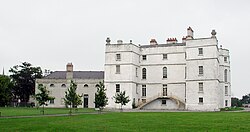
Rathfarnham Castle
Rathfarnham Castle itself was re-modelled from a defensive stronghold into a stately home. Lower Dodder Road is still marked by a triumphal arch, from this era, which originally led to the castle.

The erection of this gateway is attributed to Henry Loftus, Earl of Ely from 1769 to 1783 who was also responsible for the classical work on the castle itself. The arch is named the "new gate" on Frizell's map of 1779. After the division of the estate in 1913 the arch became the entrance to the Castle Golf Club but was later abandoned in favour of the more direct Woodside Drive entrance.
The area around the arch is a haven for wildlife, and in the nearby River Dodder live brown trout, otters and many birds including kingfisher, dipper and grey heron. Woodside Estate is home to red fox, rabbits and grey squirrels.
Ashfield
Ashfield, the next house on the same side, was occupied during the 18th century by Protestant clergy. In the early part of the 19th century it became the home of Sir William Cusac Smith, Baron of the Exchequer and from 1841 of the Tottenham family who continued in residence until 1913. After this the Brooks of Brooks Thomas Ltd.[2] occupied it until about twenty years ago when the estate was divided up and houses built along the main road. A new road was later built along the side of the house and named Brookvale after the last occupants.
Industrial revolution
An industrial revolution, especially in the production of paper, began on the Owendoher and Dodder rivers and many mills were erected. In the beginning of the 19th century most of them switched to cotton and wool and later were converted to flour mills. The introduction of steam engines marked the end of this era and replaced the need for mills. Many of the old buildings fell into disrepair and were demolished, and their millraces filled in.
A millpond and extensive mill buildings formerly occupied the low-lying fields on the west side of the main Rathfarnham road, just beside the bridge. On a map by Frizell dated 1779 it is called the "Widow Clifford's mill and mill holding" and in 1843 it is named the "Ely Cloth Factory". A Mr. Murray then owned it but in 1850, it passed into the hands of Mr. Nickson who converted it into a flour mill. His family continued in occupation until 1875 when John Lennox took over. In 1880 this mill closed down, the buildings were demolished and not a trace now remains.
About Rathfarnham Village

In the castle grounds were several fishponds which were supplied by a mill race taken from the stream which rises up at Kilmashogue and flows down through Grange Golf Club and Saint Enda's Park. This served several mills before entering the fish ponds, whence it ran through the golf links while a smaller branch was conducted under the road to the flour mills which stood at the corner of Butterfield Lane, on the site later occupied by Borgward Hansa Motors Ltd. Described in 1836 as Sweetman's Flour Mills, it frequently changed hands before closing down in 1887. It was later operated as a saw mill. The dry mill race can still be seen here on the north side of Butterfield Avenue.
Rathfarnham Protestant Parish Church on the Main Street was built in 1795 to replace the church in the old graveyard. Beside the church is the old school house that dates from early in the nineteenth century.
Immediately adjoining is Church Lane at the corner of which is a bank built on the site of a Royal Irish Constabulary barracks that was burned down by Anti-Treaty IRA forces in September 1922 during the Irish Civil War. In the lane is an old blocked up doorway of an early eighteenth century type. Church Lane leads to Woodview cottages, which are built partly on the site of an old paper mill. The mill race previously mentioned passed under Butterfield Lane to the paper mill and continued on below Ashfield to turn the wheel of the Ely Cloth Factory. It was later turned into the Owen Doher River at Woodview Cottages.
The paper mill, of which some old walls and brick arches still survive, has been described as the oldest in Ireland but there does not appear to be any evidence to support this.
Society and sport
- Scouts: 13th Dublin, 14th Dublin, 31st Dublin and the 68th Dublin Scout
- Guides: Rathfarnham Girl Guides
- Rathfarnham Concert Band
- Gaelic games:
- Ballinteer St John's GAA Club
- Ballyboden St Enda's GAA
- Football:
- Nutgrove Celtic
- Rathfarnham Punters
- Rathfarnham Rovers
- Leicester Celtic
Outside links
| ("Wikimedia Commons" has material about Rathfarnham) |
References
- ↑ Grant CCA-DCc-ChAnt/C/1206 nd [MayxNov 1175]
- ↑ "Brooks Thomas". Brooksgroup.ie. 2012-05-11. http://www.brooksgroup.ie/. Retrieved 2012-09-25.
- Archaeology, Early Christian Remains and Local Histories by Patrick Healy