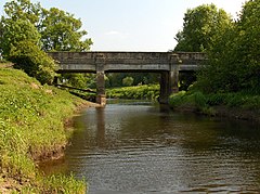
Gargunnock Bridge
| Gargunnock Bridge | |
| Perthshire, Stirlingshire | |
|---|---|
 Gargunnock Bridge | |
| Location | |
| Carrying: | B8075 (Kirk Lane) |
| Crossing: | River Forth |
| Location | |
| Grid reference: | NS71489518 |
| Location: | 56°7’55"N, 4°4’10"W |
| Structure | |
| History | |
| Information | |
Gargunnock Bridge crosses the River Forth to the north of the village of Gargunnock, between Stirlingshire on the south bank and Perthshire on the north bank. It carries Kirk Lane, the B8075.
This was once the first bridging point on the River Forth above the famous bridge at Stirling to the west: a later age added the narrow Drip Bridge between the two and modernity added the motorway.
By the south end of the bridge is a saw mill.
References
| Bridges and crossings on the River Forth | ||||||
|---|---|---|---|---|---|---|
| Cardross Bridge | Poldar Bridge | Bridge of Frew | Gargunnock Bridge | Meiklewood House Bridge | Old Drip Bridge | Drip Bridge |