Ulceby, South Riding of Lindsey
| Ulceby | |
| Lincolnshire | |
|---|---|
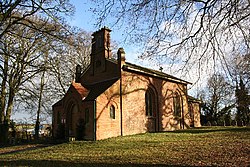
 Church of All Saints, Ulceby | |
| Location | |
| Grid reference: | TF422727 |
| Location: | 53°13’58"N, -0°7’45"E |
| Data | |
| Post town: | Alford |
| Postcode: | LN13 |
| Local Government | |
| Council: | East Lindsey |
| Parliamentary constituency: |
Louth and Horncastle |
Ulceby is a village in the South Riding of Lindsey, which sits on much of the open North Sea coast of Lincolnshire. Ulceby is inland, eight miles from the coast, next to the A1028 road, eleven miles east of Horncastle and three miles south-west of Alford.
The hamlet of Ulceby Cross lies at the intersection of the A16, A1028 and A1104 roads about a mile north-west of the village.
Outside links
| ("Wikimedia Commons" has material about Ulceby, South Riding of Lindsey) |

This Lincolnshire article is a stub: help to improve Wikishire by building it up.
