Sutton St Edmund
| Sutton St Edmund | |
| Lincolnshire | |
|---|---|
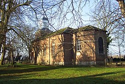
 St Edmund's church, Sutton St Edmund | |
| Location | |
| Grid reference: | TF368131 |
| Location: | 52°41’55"N, 0°1’25"E |
| Data | |
| Population: | 684 (2011, with Throckenholt) |
| Post town: | Spalding |
| Postcode: | PE12 |
| Local Government | |
| Council: | South Holland |
| Parliamentary constituency: |
South Holland and The Deepings |
Sutton St Edmunds is a village in Holland, the south-eastern part of Lincolnshire, about 14 miles south-east of the town of Spalding.
Sutton St Edmunds was a chapelry to the parish of Long Sutton until 1866. The parish includes the hamlet of Throckenholt.
The parish church, St Edmund’s, is a red-brick Grade II listed building. It was completely rebuilt in 1795, and has 19th-century alterations and extensions. It was extended again in 1987. It is a Grade II listed building.[1]
The village has a village hall.
Guarnock House is a red-brick Grade II listed building. It was built in 1699 and has a 20th-century roof.[2]
Throckenholt Priory was sited here. It was a hermitage and chapel in existence from at least 1107-1540. It was granted to Thorney Abbey by Nigel, Bishop of Ely.[3]
Outside links
| ("Wikimedia Commons" has material about Sutton St Edmund) |
References
- ↑ National Heritage List 1064538: St Edmunds Church (Grade II listing)
- ↑ National Heritage List 1204812: Guarnock House (Grade II listing)
- ↑ National Monuments Record: No. 353387 – Throckenholt Priory