Hatton, Cheshire
| Hatton | |
| Cheshire | |
|---|---|
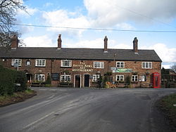
 The Hatton Arms public house, Hatton | |
| Location | |
| Grid reference: | SJ597825 |
| Location: | 53°20’15"N, 2°36’15"W |
| Data | |
| Post town: | Warrington |
| Postcode: | WA4 |
| Dialling code: | 01925 |
| Local Government | |
| Council: | Warrington |
| Parliamentary constituency: |
Warrington South |
Hatton is a small village in the north of Cheshire, sitting due south of Warrington (the latter town being across the Mersey in Lancashire) and west of the southernmost reach of Warrington's Cheshire-side suburbs.
The village is on the B5356 road between the villages of Daresbury and Stretton. The M56 motorway tickles Hatton's southernmost parts.
This is a Grade II listed building which formerly incorporated a post office and a village store.[1] Two other listed buildings are Hatton Hall and a K6 telephone kiosk designed by Giles Gilbert Scott.[2]
Outside links
| ("Wikimedia Commons" has material about Hatton, Cheshire) |
- Hatton - The village with a big community spirit: Cheshire Life
References
- ↑ National Heritage List 1329768: The Hatton Arms, Hatton
- ↑ "Hatton Village, Cheshire - Hatton Life". Hatton Life. http://www.hattonvillage.co.uk/. Retrieved 2 July 2017.
