Burley in Wharfedale
| Burley in Wharfedale | |
| Yorkshire West Riding | |
|---|---|
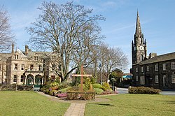
 Village green | |
| Location | |
| Grid reference: | SE165464 |
| Location: | 53°54’49"N, 1°44’53"W |
| Data | |
| Population: | 7,041 (2011[1]) |
| Post town: | Ilkley |
| Postcode: | LS29 |
| Dialling code: | 01943 |
| Local Government | |
| Council: | Bradford |
| Parliamentary constituency: |
Shipley |
Burley in Wharfedale is a village and civil parish in the West Riding of Yorkshire, within the Wharfedale valley.
The village is situated on the A65 road, approximately 11 miles north-west of Leeds city centre, eight miles north ofBradford, three miles from the spa town of Ilkley and two miles from the market town of Otley. The civil parish originates as the township of the latter's ancient parish.
The hamlet of Burley Woodhead, a cluster of farms and homes at the foot of Burley Moor, is a mile to the south-west.
History
As suggested by the Old English derivation of the village name (fortification or clearing in the River Wharfe valley),[2] Burley in Wharfedale was originally a small agricultural community with likely Roman and Anglo-Saxon roots.[3] Burley developed in the late 18th and 19th centuries into an industrial village with many residents employed at Greenholme Mills, cotton mills powered from a goit fed from the River Wharfe. The cotton mill no longer operates, but the goit is now utilised to provide hydro-electric power, and a weir remains.[4]
The development of industrial and commercial centres in the nearby cities of Leeds and Bradford, combined with rail and bus links, caused major changes to the village in the early 20th century. Council housing was built in the 1920s and 1950s, as the village became a dormitory settlement for the two cities. With developments in the second half of the 20th century, Burley became a prosperous but socially diverse village. The village has a high percentage of elderly and retired people, and young families attracted by job opportunities, local schools and new housing developments.[5]
In 2006, following a petition to the local authority and permission from Parliament, Burley gained its own Parish Council.[6]
Community

The village contains a range of local businesses. Burley public buildings include the Queens' Hall, originally built as a lecture hall for mill workers. Recent work by community groups has resulted in developments including a new nature reserve, and the village green which contains a central water feature.[7]
The village has two state primary schools, Burley and Woodhead Primary School, Burley Oaks Primary School, and Ghyll Royd School & Pre-School,[8] a private primary and nursery school for girls and boys aged 2–11. The school was established in 1889 by Augustus Wooldridge Godby. Formerly an all boys school, it became a co-educational school in 1999 when it moved location to Greystone Manor.[9]
Burley churches are those for Anglicans, Calvinists, Methodists, and Catholics. The Anglican Parish Church is dedicated to St Mary.[10]
Burley has a range of housing types and age, and terrace houses and cottages at the centre. Scalebor Park Hospital has been converted into private townhouses and flats.[11]
Burley has a railway station on the Wharfedale Line, with direct trains to Leeds, Bradford and Ilkley, and links to other local urban areas.[12]
References
- ↑ UK Census (2011). "Local Area Report – Burley in Wharfedale Built-up area (E35001500)". Nomis. Office for National Statistics. https://www.nomisweb.co.uk/sources/census_2011_ks/report?compare=E35001500. Retrieved 18 June 2019
- ↑ Ekwall, Eilert (1960). The Concise Oxford Dictionary of English Place-names (4 ed.). Oxford: Clarendon Press. p. 75. ISBN 0-19-869103-3.
- ↑ "Burley-in-Wharfedale conservation area assessment" (PDF). 2004. p. 5. https://www.bradford.gov.uk/media/2344/burleyinwharfedaleconservationareaassessment.pdf. Retrieved 18 June 2019.
- ↑ "New lease of life for Burley mill as river power harnessed". Wharfedale Observer. 14 August 2011. http://www.wharfedaleobserver.co.uk/news/9191111.NewleaseoflifeforBurleymillasriverpowerharnessed/. Retrieved 1 October 2017.
- ↑ "Bradford Growth Assessment" (PDF). Broadway Malyan. November 2013. p. 12. https://www.bradford.gov.uk/Documents/EvidenceBase/Bradford%20Growth%20Assessment/C.%20Local%20Growth%20Centres.pdf. Retrieved 1 October 2017.
- ↑ "Board to honour Burley Parish Council chairmen". Wharfedale Observer. 4 January 2014. https://www.wharfedaleobserver.co.uk/news/10910493.board-to-honour-burley-parish-council-chairmen/. Retrieved 18 June 2019.
- ↑ "Wharfedale's new nature reserve". BBC News. 17 June 2011. https://www.bbc.co.uk/news/uk-england-leeds-13795907. Retrieved 18 June 2019.
- ↑ "Home". http://www.ghyllroydschool.co.uk. Retrieved 25 November 2016.
- ↑ "Contact Us". Ghyll Royd School and Pre-School. http://www.ghyllroydschool.co.uk/contact-us.
- ↑ "Burley-in-Wharfedale: St Mary the Blessed Virgin - A Church Near You". https://www.achurchnearyou.com/church/6851/. Retrieved 18 June 2019.
- ↑ "Scalebor Park Hospital". County Asylums. https://www.countyasylums.co.uk/scalebor-park-burley-in-wharfedale/. Retrieved 18 April 2019.
- ↑ "Burley in Wharfedale: A Sustainable Development Location" (PDF). Nathaniel Lichfield & Partners. February 2015. p. 7. https://www.bradford.gov.uk/Documents/planningStrategy/06%20Examination/05%20Documents%20submitted%20by%20other%20parties%20-%20further%20statements//PS%20D025u%20-%20Further%20statement%20matter%203.2%20Appx%201%20Burley%20sustainable%20development%20location%20report%20495.pdf. Retrieved 18 June 2019.
Outside links
| ("Wikimedia Commons" has material about Burley in Wharfedale) |