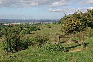
Dover's Hill
| Dover’s Hill | |||
| Gloucestershire | |||
|---|---|---|---|
 Dover's Hill | |||
| Range: | Cotswolds | ||
| Summit: | 754 feet SP136396 52°3’18"N, 1°48’8"W | ||
Dover's Hill is a hill of 754 feet in the Cotswolds, in Gloucestershire. The hill is a mile north-west of Chipping Campden.[1]
Dover's Hill and the surrounding land is the property of The National Trust.[2]

On the top of the hill is a trig point, and also a toposcope illustrating many of the landmarks that are visible from it. These include the Black Mountains in Brecknockshire and the Long Mynd in Shropshire (nearly sixty miles away).[1]
A monument of 1934 commemorates Robert Dover, founder of the Cotswold Olimpick Games, precursor of the modern Olympic Games.[3]
Outside links
| ("Wikimedia Commons" has material about Dover's Hill) |
- Dover's Hill: National Trust
References
- ↑ 1.0 1.1 Beautiful Britain: Heart of England. AA Publishing. 1988. p. 48. ISBN 0861457234.
- ↑ "Robert Dover's Olimpick Games". www.chippingcampden.co.uk/. http://www.chippingcampden.co.uk/contentok.php?id=672. Retrieved 22 July 2015.
- ↑ "A Brief History of Robert Dover's Games". Robert Dovers Games Society. http://www.olimpickgames.com/history/. Retrieved 22 July 2015.
