Bridstow
| Bridstow | |
| Herefordshire | |
|---|---|
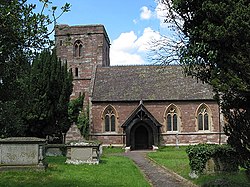
 St Bridget's Church, Bridstow | |
| Location | |
| Grid reference: | SO583247 |
| Location: | 51°55’12"N, 2°36’18"W |
| Data | |
| Population: | 859 (parish) |
| Post town: | Ross-On-Wye |
| Postcode: | HR9 |
| Dialling code: | 01989 |
| Local Government | |
| Council: | Herefordshire |
| Parliamentary constituency: |
Hereford and South Herefordshire |
Bridstow is a village in Herefordshire a mile and a half west of Ross-on-Wye and ten miles south-east of Hereford.
The parish is bounded to the east and south by the River Wye. The A40 road linking the M50 motorway to Monmouthshire runs through the parish, crossing the Wye at Bridstow Bridge.
The parish had a recorded population of 859 at the 2001 Census.
Parish church
The parish church, dedicated to St Bridget, has a tower in the Perpendicular style, but the rest of the exterior was rebuilt in 1862 to a design by Thomas Nicholson. The stained glass is by Charles Kempe.[1]
About the parish
The largest village in the parish is Wilton, site of the Grade I listed Wilton Castle and Wilton Bridge.
The village has a village hall.
Outside links
| ("Wikimedia Commons" has material about Bridstow) |
References
- ↑ Nikolaus Pevsner: The Buildings of England: Herefordshire, 1963; 2012 Penguin Books ISBN 978-0-300-12575-7
