Ysbyty Ifan
| Ysbyty Ifan | |
| Denbighshire | |
|---|---|
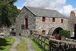
 Ysbyty Ifan, watermill | |
| Location | |
| Grid reference: | SH842488 |
| Location: | 53°1’27"N, 3°43’37"W |
| Data | |
| Postcode: | LL24 |
| Local Government | |
| Council: | Conwy |
Ysbyty Ifan is a small but historic village high in the hills on the River Conwy, spread across the boundary of Denbighshire and Caernarfonshire, which border the river forms. The High Street, the church and the heart of the village are on the eastern bank of the river Denbighshire, but several streets are to the west, in Caernarfonshire.
The village
Ysbyty Ifan had a population of 221 people at the 2001 Census and is almost wholly Welsh-speaking.
There is a good range of local shops in Ysbyty Ifan, a children's playground and a village primary school. It has a rugby union pitch. The village is joined together by a single bridge over the infant River Conwy.
The parish church contains memorial slabs to Rhys Fawr ap Maredudd (fl. 1485-1510), a local nobleman who served Henry VII at the Battle of Bosworth Field, and to his wife Lowri.
The cottage of Foel Gopyn is a National Trust property.
Name and history
Ysbyty Ifan, until 1189, was known as Dôl Gynwal. Then, it came to the attention of the Knights of St John, who set a hospice up here, whence the village's name, which means "Hospital of John". The church marks the spot where the old hospice stood, and it contains many remnants that tell of the area's rich history.
Outside links
| ("Wikimedia Commons" has material about Ysbyty Ifan) |
