Henry's Moat
| Henry's Moat Welsh: Castell Hendre | |
| Pembrokeshire | |
|---|---|
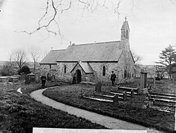
 St Brynach's Church, about 1885 | |
| Location | |
| Location: | 51°54’47"N, 4°50’46"W |
| Data | |
| Post town: | Clarbeston Road |
| Postcode: | SA63 |
| Local Government | |
| Council: | Pembrokeshire |
| Parliamentary constituency: |
Preseli Pembrokeshire |
Henry’s Moat is a hamlet and ancient parish in the Cemais Hundred of Pembrokeshire. It is seven miles south-east of Fishguard and nine miles north-east of Haverfordwest. The nearest railway station is Clarbeston Road, five miles to the south. The parish church is dedicated to St Brynach (English: St Bernard).[1]
Name
The parish’s Welsh name was Castell Hên-drêv (or Hendre), Anglicised by early English settlers to its present form. It derives from an ancient tumulus surrounded by a moat.[1]
History
In 1833 the population of the parish was 282.[1] It includes the hamlet of Tufton on the nearby B4329 Cardigan to Haverfordwest turnpike.[2]
References
| ("Wikimedia Commons" has material about Henry's Moat) |
- ↑ 1.0 1.1 1.2 "GENUKI: Henry’s Moat". http://www.genuki.org.uk/big/wal/PEM/HenrysMoat/index.html. Retrieved 25 April 2015.
- ↑ "GENUKI: Parish maps". http://www.genuki.org.uk/big/wal/PEM/Letterston/ParishMap.html. Retrieved 25 April 2015.
