Clachtoll
| Clachtoll Gaelic: Clach Toll | |
| Sutherland | |
|---|---|
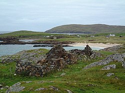
 The remains of Black Houses overlooking Clachtoll Bay | |
| Location | |
| Grid reference: | NC039269 |
| Location: | 58°11’17"N, 5°20’15"W |
| Data | |
| Post town: | Lairg |
| Postcode: | IV27 4 |
| Local Government | |
| Council: | Highland |
Clachtoll is a coastal fishing and crofting village, situated on the Bay of Clachtoll, on the west coast of Sutherland, in the ancient parish of Assynt.[1]
The place derives its name from the Gaelic and refers to the very large broken rock, the remains of a natural arch, on the headland nearby - from clach ("rock") and toll meaning "hole" or "cavity".
| ("Wikimedia Commons" has material about Clachtoll) |
References
- ↑ "Clachtoll". School of GeoSciences, University of Edinburgh and The Royal Scottish Geographical Society. http://www.scottish-places.info/towns/townfirst2361.html. Retrieved 17 June 2018.
