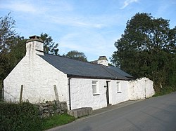
Dolbenmaen
| Dolbenmaen | |
| Caernarfonshire | |
|---|---|
 Bod Hyfryd | |
| Location | |
| Grid reference: | SH5043 |
| Location: | 52°58’5"N, 4°13’41"W |
| Data | |
| Population: | 1,300 (2001) |
| Post town: | Garndolbenmaen |
| Postcode: | LL51 |
| Dialling code: | 01766 |
| Local Government | |
| Council: | Gwynedd |
| Parliamentary constituency: |
Caernarfon |
Dolbenmaen is a village in Caernarfonshire, in the area known as Eifionydd. Surrounding villages and hamlets of the parish include Bryncir, Cenin, Garndolbenmaen, Golan, Llanfihangel-y-pennant, Penmorfa and Pentrefelin, and had a population of 1,300 at the 2001 census.
The summit of Moel Hebog is shared between the parishes of Beddgelert and Dolbenmaen.