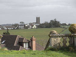
St Giles in the Wood
| St Giles in the Wood | |
| Devon | |
|---|---|
 St Giles in the Wood | |
| Location | |
| Grid reference: | SS533190 |
| Location: | 50°57’7"N, 4°5’19"W |
| Data | |
| Local Government | |
| Council: | Torridge |
St Giles in the Wood is a village in northern Devon, about two and a half miles east of the town of Great Torrington.
The 2001 census recorded a parish population of 566, compared with 623 recorded in 1901,[1] The parish is surrounded clockwise from the north by the parishes of Huntshaw, Yarnscombe, High Bickington, Roborough, Beaford, Little Torrington and Great Torrington.[2] There are also a number of hamlets in the parish including High Bullen, Healand and Kingscott (where there is a Baptist chapel dating from 1833, and a late 19th-century school).[3] In the south-west of the parish is the Royal Horticultural Society's Rosemoor Garden.[1]
Most of the Victorian terraced cottages in the village, on the east side of the church, were built by the Rolle Estate.[3]
Within the parish are several historic residences: Stevenstone (the historic seat of the Rolle family), Way Barton (home of the Pollard baronets), Winscott (where Tristram Risdon, author of the Survey of Devonshire, was born, c. 1580), Dodscott and Woodleigh Barton.
Parish church
The large parish church in the village is dedicated to St Giles the Hermit and came into being in 1309 when licence was obtained from the Bishop of Exeter to build a chapel of ease because the church at Great Torrington was considered too far for the convenience of the local inhabitants.
Mark Rolle funded the restoration of the church in 1862–3 and many old monuments were retained; these include the monument and effigy of Thomas Chafe (d. 1648) of Dodscott, three monumental brasses, of Alenora Pollard (d. 1430), Margaret Rolle of Stevenstone (d. 1592) and a small brass of her husband John Rolle (d.1570). There are also 19th- and 20th-century monuments to the Rolle family.[4]

Historic houses
Stevenstone House, now demolished, was the most notable historic residence within the parish. It was the seat of the Rolle family since the 16th century, which when held by Hon. Mark Rolle (d.1907) were the largest landowners in Devon with over 55,000 acres.
Way Barton stands about two miles north-east of the village. W. G. Hoskins described it in 1959 as the origin of the Pollard family, having been acquired by them from the de la Way family at some time before 1242.[5]

Winscott is a large farmhouse, built on the site of the mansion house belonging to Tristram Risdon, an early historian of Devon who died in 1640.[6] In the 16th century Winscott was the property of the Barry family, according to Risdon a branch of the ancient de Barry family that had large landholdings around Cork in Ireland. After passing through the Risdon family, it descended into the family of Northcote, ancestors of Stafford Northcote, 1st Earl of Iddesleigh.
Dodscott is now a hamlet, about three-quarters of a mile north-east of the parish church and the same distance north-west of Winscott. The manor is listed in the Domesday Book of 1086 when it was one of 28 manors held by Gotshelm, who had sub-enfeoffed it to his tenant Walter of Burgundy. It was the cottage of the cottar Doda before 1066, and paid tax for one virgate of land, with land for 1 1/2 ploughs.[7] In the 16th century Dodscott was the residence of Thomas Chafe (1585-1648), the brother-in-law of his neighbour Tristram Risdon of Winscott. Risdon wrote a brief paragraph on the history of Dodscott but did not mention how it had come into the possession of Chafe.
Outside links
| ("Wikimedia Commons" has material about St Giles in the Wood) |
References
- ↑ 1.0 1.1 Harris, Helen (2004). A Handbook of Devon Parishes. Tiverton: Halsgrove. p. 143. ISBN 1-84114-314-6.
- ↑ "Map of Devon Parishes". Devon County Council. http://www.devon.gov.uk/devon_districts_2002_.pdf. Retrieved 20 June 2013.
- ↑ 3.0 3.1 Nikolaus Pevsner: The Buildings of England: Devon, 1952; 1989 Penguin Books ISBN 978-0-300-09596-8page 707
- ↑ Nikolaus Pevsner: Pevsner Architectural Guides
- ↑ Hoskins, W.G., A New Survey of England: Devon, London, 1959 (first published 1954), p.470
- ↑ Risdon, Tristram (1811). Rees. ed. The Chorographical Description or Survey of the County of Devon (updated ed.). Plymouth: Rees and Curtis. p. v. https://books.google.com/books?id=uIdnAAAAMAAJ.
- ↑ Thorn, Caroline & Frank, (eds.) Domesday Book, (Morris, John, gen. ed.) Vol. 9, Devon, Parts 1 & 2, Phillimore Press, Chichester, 1985, chap. 25, section 4
- Nikolaus Pevsner: The Buildings of England: Devon, 1952; 1989 Penguin Books ISBN 978-0-300-09596-8
