Chirbury
| Chirbury Welsh: Llanffynhonwen | |
| Shropshire | |
|---|---|
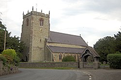
 St Michael's church, Chirbury | |
| Location | |
| Grid reference: | SO261983 |
| Location: | 52°34’42"N, 3°5’31"W |
| Data | |
| Population: | 348 (2001) |
| Post town: | Montgomery |
| Postcode: | SY15 |
| Dialling code: | 01938 |
| Local Government | |
| Council: | Shropshire |
| Parliamentary constituency: |
Ludlow |
Chirbury is a village in western Shropshire, in the Vale of Montgomery, just a mile from the boundary of Montgomeryshire, whose boundaries curl around this little Shropshire parish to the north, west and south. The A490 and B4386 routes cross at Chirbury.
Chirbury shares a civil parish with neighbouring Brompton, Shropshire, as 'Chirbury with Brompton'. According to the 2001 Census, the parish had a population of 914, with the resident population of Chirbury itself at just 348.
Name
The name of Chirbury was recorded in 915 in the Anglo-Saxon Chronicle as Cyricbyrig (dative), and in the Domesday Book of 1086 as Cireberie. The name means "Church fort" or "Church town".
The Welsh name of the village is Llanffynhonwen, which means "Church of the White Well".
Geography
The village is two and a half miles east of Montgomery and 8½ miles north-west of Bishop's Castle, with Shrewsbury, the county town, 18 miles away to the northeast.

The civil parish, Chirbury with Brompton, includes:
- Brompton
- Marton
- Middleton
- Pentreheyling
- Priestweston
- Rorrington
- Stockton
- Wotherton.
It is not possible to reach Brompton or Pentreheyling by a public road without passing through Montgomeryshire, though footpaths cross the fields to them.
The eastern part of the parish falls within the Shropshire Hills Area of Outstanding Natural Beauty.
Through the parish flows the River Camlad, which flows first to the east and then to the north of the village, on its way from Church Stoke (in the south) to its confluence with the River Severn (in the north-west).
History and historical legacy
The 8th century Offa's Dyke runs to the west of the village, and marked the frontier of the Mercian kingdom, and even today a lengthy section of the dyke to the south-west of the village forms the boundary with Montgomeryshire. An Anglo-Saxon fort, built in 915 by Æthelflæd, Lady of the Mercians, was located just outside the village on what is now the Montgomery Road; the field the earthworks are in has long been called Castle Field or King's Orchard.[1]
Chirbury also gave its name to the Chirbury Hundred of the county, though formerly it was part of a larger hundred[2] named Witentreu (or possibly in Old English Witantreow)[3] later Wittery[4] (a placename that continues to this day in Whittery Wood, near to the village). The hundred includes a detached township near Clun: Guilden Down.[5]
Mitchell's Fold and Hoarstones stone circles lie within the parish.
Church
St Michael's Church, as pictured in the infobox above, is the only church in Chirbury. It is dedicated to St Michael the Archangel and within the Diocese of Hereford.
Originally an Anglo-Saxon church, founded in 915 (with the building of the fort) or possibly earlier, the current building largely dates to the late 12th century with the tower constructed around 1300, and a short chancel added in 1733. The church was restored in 1871–72 by Edward Haycock junior. The tower and body of the church are constructed in limestone rubble with pink sandstone ashlar dressings and slate roofs; the chancel is in red brick with a tiled roof.[6][7] The church was reformed into the priory church of the Augustinian Chirbury Priory when the order moved from nearby Snead by 1227.[7]
With the dissolution of the priory under Henry VIII in 1535, St Michael's became a parish church once again;[8][2][9]
The church building is a Grade I Listed building.[7] Remnants of the former priory can be seen in the churchyard[10] and some stonework was also incorporated into the adjacent Chirbury Hall.
Conservation area
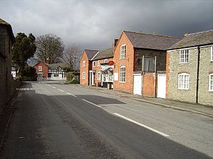
The centre of Chirbury is a conservation area, which includes Chirbury Hall, St Michael's Church, The Herbert Arms, Chirbury Primary School and the Parish Hall.[11] Most of the village's buildings are either of a red brick or limestone construction, or a combination.
About the village

In the village is a village hall (the Parish Hall), a large public house called The Herbert Arms,[12] and a post office which is also the village shop.
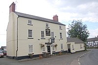
The Herbert Arms is named for the Barons Herbert of Chirbury and historically was a coaching inn, sometimes called the Herbert Arms Hotel (though it no longer is a hotel). Built in the 18th century in red brick (painted white) it was originally called The Cross,[13] and is Grade II Listed.[14]
The village has a primary school and a nursery school ('Busy Bees').
Sport
There is a bowls club with its own bowling green in the village.
Outside links
| ("Wikimedia Commons" has material about Chirbury) |
References
- ↑ Raven, M A Guide To Shropshire (2005) p 50
- ↑ 2.0 2.1 MELOCKI Chirbury
- ↑ Clwyd-Powys Archaeological Trust
- ↑ Open Domesday Wittery hundred
- ↑ GENUKI Shropshire hundreds
- ↑ Newman & Pevsner 2006, pp. 199–200.
- ↑ 7.0 7.1 7.2 Church of St Michael Chirbury - British Listed Buildings
- ↑ History of St Michaels
- ↑ Dissolution of Chirbury Priory
- ↑ Discovering Shropshire's History Chirbury Priory
- ↑ Shropshire Council Chirbury conservation area map
- ↑ The Herbert Arms at Chirbury
- ↑ Smart, R Pub Strolls in Shropshire (2003) p 53
- ↑ Herbert Arms Hotel - British Listed Buildings
