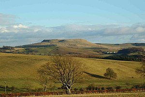
Burnswark Hill
| Burnswark Hill | |||
| Dumfriesshire | |||
|---|---|---|---|
 Burnswark Hill, Dumfriesshire | |||
| Range: | Southern Uplands | ||
| Summit: | 942 feet NY185786 55°5’44"N, 3°16’42"W | ||
Burnswark Hill stands amongst the Southern Uplands within Dumfriesshire, at the east side of Annandale, the great dale cut through the shire. Its main feature is an Iron Age hill fort of great historical interest covering 17 acres of its summit. Known as Burnswark, this fort gives a name to the hill.
The importance of the hill in a past age comes from its position beside the dale, which bears the main transport routes through the Southern Uplands. The old Roman road through the dale passes beneath the gaze of the hill's ramparts, while today's A74(M) motorway and B7076 and the West Coast Main Line run just to the east.
The northern and southern slopes of the hill bear the remains of two Roman forts and ordnance found scattered over Burnswark Hill tell that it was once the site of a fearsome battle to secure the hillfort and the road up Annandale.
Outside links
| ("Wikimedia Commons" has material about Burnswark Hill) |

