Barley, Hertfordshire
| Barley | |
| Hertfordshire | |
|---|---|
 St Margaret of Antioch, Barley | |
| Location | |
| Grid reference: | TL400385 |
| Location: | 52°1’38"N, -0°2’29"E |
| Data | |
| Population: | 659 (2001) |
| Post town: | Royston |
| Postcode: | SG8 |
| Dialling code: | 01763 |
| Local Government | |
| Council: | North Hertfordshire |
| Parliamentary constituency: |
North East Hertfordshire |
Barley is a village in northern Hertfordshire, standing on the Royston to Saffron Walden road, as well as the mediæval London to Cambridge road. The 2001 census recorded a population of 659.
The name of the village is Old English, recorded as Berlei in the Domesday Book. It is said to mean “Beora's Clearing” (Beornan leah), presumably after an early lord named Beora, though Bere leah (“Barley meadow”) would be possible too, but for the unlikelness of growing barley in a “ley” (untilled open land). Coincidentally to the southwest lies the village of Reed.
The Greenwich Meridian passes to the west of Barley.
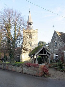
The parish church is dedicated to St Margaret of Antioch.[1] It has a 12th-century Norman tower, though the rest of the church was rebuilt in 1872 to the designs of William Butterfield, and only the tower and the fourth aisle were retained.[2]
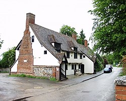
The Town House

The Town House is one of the oldest buildings in the village, a community hall which has belonged to the village for nearly 500 years. It may be the oldest village halls in the county, and one of the oldest in the land.
The Town House was used in the 16th century as the Court House of the Manor of Mincinbury, but the villagers would not let the lord of the manor keep hold of what was their own village hall, not a private hall. At a court held at Buntingford in 1609 the jury decided that the Town House was to be used:
for the poor inhabitants, for their marriages, to collect and cause by meeting, the gifts of the charitable people to be obtained towards the help and relief of the poor inhabitants within the said town ..... and also for a school house, and so it has been for time out of mind until the late Sir John Spencer Kt, Alderman of London, has made claim to the said house.
Sir John and his heirs were ordered not to 'vex the parishioners in their holding'.
The Buntingford charities inquisition of 1638 gave the Town House date as 1530 and stated:
the saide house hath been tyme out of mynde used and ymploied for the keeping of maides marriages therein and for the hangeing up of the Town Arms therein, and for the chief inhabitants there to mete and consult of the affairs and common busynesses of the Town of Barley.
The Rector stated that 'keeping of maides marriages' meant homes for spinsters and not wedding celebrations.
In 1726 Daniel Defoe wrote that upstairs there is a large room for entertainment feasting and merriment; a small room to the side for the preparation of food with a spit, large cauldron and dripping pan; a room at the end of the main room which contained a bride bed and good linen, for the couple to spend their first night to consummate their wedding.[3]
It is believed locally that the Town House replaces a yet older building which had stood for about 400 years, given to the village by Alfwen who had been nurse to King Edgar.
Historical interest
The area has been home to residents for perhaps 3,000 years; evidence has been found of Bronze Age settlers in the hills around Royston and Iron Age farmers to the north of the village in 100 BC, and Romans again occupied the parish.[1]
The Plaistow is a plot of two acres of land given to the people of the village by King Edgar in the 10th century.
In the stands a 17th-century lock-up and an early Tudor town house with a large timbered upper room, which was mentioned by Daniel Defoe in his Tour through the Whole Island of Great Britain in 1726.
Village life
Barley is home to a junior school, playground, village green, tennis courts, cricket team, stables, football team, petrol station and a post office and store. There are regular bus services to Royston and Hertford.
There is a steady flux of people moving into and out of the village, and a substantial commuter element (Royston station is only 10 minutes' drive away, whence it is only 35 minutes to Kings Cross), though this has not displaced the many long-established families of the village.
A well-known landmark in the village is the sign of the Fox and Hounds public house, a gantry which stretches across the road at the top of Church End with pictures of a fox and hounds racing across the top. Although it is a long-established feature of the village, it has not always been at its present site. In 1955 the Fox and Hounds, with its famous sign, was a pub located in the High Street, at the time part of an important route to London. In 1955 the Fox & Hounds burned down in a disastrous fire. The sign, which was partially saved, moved to its present site and the existing pub (the Wagon and Horses) was renamed. There are now two pubs in the village, the other being the Chequers.
Outside links
| ("Wikimedia Commons" has material about Barley, Hertfordshire) |
