Snow Hill Island
| Snow Hill Island | |
 Snow Hill Island, January 1999 | |
|---|---|
| Location | |
| Location: | 64°27’58"S, 57°10’59"W |
| Data | |
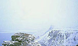
Snow Hill Island is an almost completely snowcapped island in the James Ross Island Group off the east coast of Graham Land in the British Antarctic Territory. It is separated from James Ross Island to the north-east by Admiralty Sound and from Seymour Island to the north-east by Picnic Passage.
The island is twenty miles long and seven and a half miles wide.
Discovery and exploration
The island was discovered on 6 January 1843 by a British expedition under James Clark Ross and roughly mapped, the chart showing it as part of the mainland's Trinity Peninsula. Ross was uncertain as to whether it was an island or part of the Trinity Peninsula, to which it is connected by ice, and named it 'Snow Hill' because no rock was visible through the cover of snow and ice, the snow-clad hill standing out in contrast to the bare ground of nearby Seymour Island.
Snow Hill's status as a separate island was determined on 10 March 1902 by the Swedish Antarctic Expedition of 1902-03 organised by Otto Nordenskjöld in the ship Antarctic. The Swedish expedition spent the winters of 1901, 1902, and 1903 here, using Snow Hill as a base to explore the neighbouring islands and the adjacent coast of Graham Land, now known as the Nordenskjold Coast.[1]
The Antarctic was caught and crushed in the ice and sank 25 miles off Paulet Island on 12 February 1903 leaving the men of the Swedish Antarctic Expedition stranded until rescued by the Argentinian sloop-of-war Uruguay under Captain Julián Irízar. In gratitude, the Swedes named two nearby islands 'Irizar' and 'Uruguay', (although the names were later changed by the Falkland Islands Dependencies Survey as the same names had been given to two islands in Wilhelm Archipelago, likewise in tribute to the rescue).
n 1934-35 Ellsworth visited the Swedish station in the Wyatt Earp and from there made a flight south-west over the Antarctic Peninsula in his ski-equipped aircraft Polar Star, piloted by Bernt Balchen. The Swedish station was visited again by a the Falkland Islands Dependencies Survey sledge party from Hope Bay in 27-28 August 1945.
The island was resurveyed by the Falkland Islands Dependencies Survey from Hope Bay in 1952-54. An Argentine refuge hut was built in 1954 at 64°22’0"S, 57°1’0"W near Haslum Crag on Snow Hill called Suecia, meaning 'Sweden', in honour of the Swedish Antarctic Expedition.
Historic site

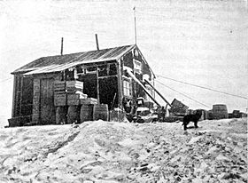
The wooden hut built by the main party of the Swedish Expedition in February 1902, also known as Nordenskiöld House, has been designated a Historic Site or Monument (HSM 38), following a proposal by Argentina and the United Kingdom to the Antarctic Treaty Consultative Meeting.[2]
Important Bird Area
A site at the south-western extremity of the island, comprising 650 acres of sea ice adjacent to the coast, has been identified as an 'Important Bird Area' by BirdLife International because it supports a breeding colony of about 4000 pairs of emperor penguins. It is one of only two such colonies on land of the Antarctic Peninsula region, the other being that at the Dion Islands.[3]
References
- ↑ Stonehouse (2002)
- ↑ "List of Historic Sites and Monuments approved by the ATCM (2012)". Antarctic Treaty Secretariat. 2012. http://www.ats.aq/documents/ATCM35/WW/atcm35_ww003_e.pdf. Retrieved 2013-12-31.
- ↑ Snow Hill Island IBA: BirdLife International
- Gazetteer and Map of The British Antarctic Territory: Snow Hill Island
- Antarctica. Sydney: Reader's Digest, 1985, pp. 152–159..
- Child, Jack. Antarctica and South American Geopolitics: Frozen Lebensraum. New York: Praeger Publishers, 1988, pp. 69, 72.
- Lonely Planet, Antarctica: a Lonely Planet Travel Survival Kit, Oakland, CA: Lonely Planet Publications, 1996, 307.
- Stewart, Andrew, Antarctica: An Encyclopedia. London: McFarland and Co., 1990 (2 volumes), p 931.
- Stonehouse, Bernard: Encyclopedia of Antarctica and the Southern Oceans, John Wiley and Sons, 2002. ISBN 0-471-98665-8
- U.S. National Science Foundation, Geographic Names of the Antarctic, Fred G. Alberts, ed. Washington: NSF, 1980.