Gawthrop
| Gawthrop | |
| Yorkshire West Riding | |
|---|---|
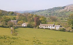
 Gawthrop village, Dentdale | |
| Location | |
| Grid reference: | SD692873 |
| Location: | 54°16’52"N, 2°28’23"W |
| Data | |
| Post town: | Sedbergh |
| Postcode: | LA10 |
| Dialling code: | 015396 |
| Local Government | |
| Council: | Westmorland & Furness |
| Parliamentary constituency: |
Westmorland and Lonsdale |
Gawthrop is a hamlet in the West Riding of Yorkshire, amongst the Yorkshire Dales and within the bounds of the National Park of that name.
The hamlet is near the River Dee and the village of Dent, also in the West Riding.
Outside links
| ("Wikimedia Commons" has material about Gawthrop) |
