Ewanrigg
| Ewanrigg | |
| Cumberland | |
|---|---|
 Ewanrigg | |
| Location | |
| Grid reference: | NY039355 |
| Location: | 54°42’18"N, 3°29’28"W |
| Data | |
| Population: | 3,447 (2011) |
| Post town: | Maryport |
| Postcode: | CA15 |
| Dialling code: | 01900 |
| Local Government | |
| Council: | Cumberland |
| Parliamentary constituency: |
Workington |
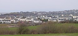
Ewanrigg is a village which has developed to become an outer suburb of the town of Maryport, in Cumberland. Ewanrigg is a residential area and has a post office, a school and a few places of worship, an has industrial areas to the west running towards the coast. Ellenborough is a suburb to the east.
The village, or suburb, stands near the River Ellen and is only about a mile away from the estuary, which empties into the Irish Sea.
The A594 road runs through Ewanrigg and the A596 road passes nearby.