Cleator
| Cleator | |
| Cumberland | |
|---|---|
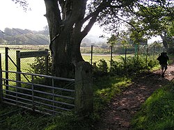
 Coast-to-Coast Path, near Cleator | |
| Location | |
| Grid reference: | NY015135 |
| Location: | 54°30’29"N, 3°31’16"W |
| Data | |
| Post town: | Cleator |
| Postcode: | CA23 |
| Dialling code: | 01946 |
| Local Government | |
| Council: | Cumberland |
| Parliamentary constituency: |
Copeland |
Cleator is a village in Cumberland. It stands a mile and a half south of the town of Cleator Moor on the A5086 road: Cleator was the original village, while Cleator Moor being the moor above the village on which a hamlet grew to surpass its mother village.
Cleator is beside the River Ehen, which is joined by the River Keekle at Longlands Lake, and is near the historic port town of Whitehaven.
The village is the site of the former Kangol hat factory, though the factory buildings and shop are now closed.
History
Cleator was the site of a number of mills (originally linen). This was how Kangol came to be located at Cleator. Following the development of iron ore mining in nearby areas, Cleator was site of associated works (hence the street name "Kiln Brow" and the location "The Forge"). Longlands Lake nature reserve is on the site of the former Longlands iron ore mine that first produced ore in 1879 from four pits. By 1924 the mines had been abandoned. In 1939 the mines started to subside and flood the area creating Longlands Lake. Longlands was acquired by Cumbria County Council in 1980.
During the West Cumberland floods on 2009 the village was severely affected: on Thursday 19 November 2009, rainfall of over twelve inches was recorded across the county, causing a surge off the fells of the Lake District: the River Ehen burst its banks at Cleator, near to the Kangol factory, flooding fields and a number of residential properties. Cleator Flood Action Group, associated to the National Flood Forum, was established following this event, in order to work with relevant agencies to progress actions to prevent or reduce the consequences of any future flood events.
Churches
- Church of England: St Leonard's, which dates to the 12th century.
- Roman Catholic: St Mary's, designed by E W Pugin and opened in 1872. It has a grotto, constructed in 1926 to give work to the unemployed men of the parish during the depression, which mimics that of Lourdes and is the venue for an annual procession.
Sport and leisure
Cleator lies on Alfred Wainwright's Coast to Coast Walk and is on the edge of the Lake District, with Dent Fell on the skyline to the south-east.
- Crocket: Cleator Cricket Club, whose home is the picturesque J.D. Campbell Memorial Ground.
Outside links
| ("Wikimedia Commons" has material about Cleator) |
