Cargo
| Cargo | |
| Cumberland | |
|---|---|
 Cargo Farm | |
| Location | |
| Grid reference: | NY365592 |
| Location: | 54°55’23"N, 2°59’20"W |
| Data | |
| Post town: | Carlisle |
| Postcode: | CA6 |
| Dialling code: | 01228 |
| Local Government | |
| Council: | City of Carlisle |
| Parliamentary constituency: |
Penrith and The Border |
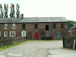
Cargo is a small village near the mouth of the River Eden on the Solway Plain of Cumberland, about three and a half miles north-west of Carlisle.
The name Cargo reflects a combination of two languages; from the Cumbric or Old Welsh word carreg meaning "rock" and the Old Norse word haugr meaning "hill".
Outside links
| ("Wikimedia Commons" has material about Cargo) |
