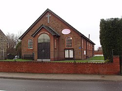
Great Houghton, Yorkshire
| Great Houghton | |
| Yorkshire West Riding | |
|---|---|
 Great Houghton Methodist Church | |
| Location | |
| Grid reference: | SE432065 |
| Location: | 53°33’-0"N, 1°21’0"W |
| Data | |
| Population: | 2,475 (2011) |
| Post town: | Barnsley |
| Postcode: | S72 |
| Dialling code: | 01226 |
| Local Government | |
| Council: | Barnsley |
| Parliamentary constituency: |
Barnsley East and Mexborough |
Great Houghton is a village in the West Riding of Yorkshire, standing to the west of Thurnscoe on the B6411 road. At the 2011 census, Great Houghton had a population of 2,475.
This is a former mining village, whose mines were served by the railway, but the mines have long closed and the railway has since gone too, though remains are still visible.
The village has a primary school, Sandhill.[1]
Some parts of Great Houghton were affected by the 2007 summer flooding, which caused extensive damage in neighbouring villages.
Outside links
| ("Wikimedia Commons" has material about Great Houghton, Yorkshire) |
