Banks, Cumberland
| Banks | |
| Cumberland | |
|---|---|
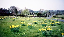
 Village green, Banks | |
| Location | |
| Grid reference: | NY565646 |
| Location: | 54°58’29"N, 2°40’47"W |
| Data | |
| Post town: | Brampton |
| Postcode: | CA8 |
| Dialling code: | 016977 |
| Local Government | |
| Council: | Cumberland |
| Parliamentary constituency: |
Penrith and The Border |
Banks is a village in the north of Cumberland, astride the course of Hadrian's Wall, on a rising slope north of the River Irthing. The village is to be found three miles north-east of the market town of Brampton. The ruins of Lanercost Priory lies just a mile to the south-west.

Banks East Turret (a Roman turret following Milecastle 52 on the Wall is a relatively well-preserved turret with adjoining stretches of Hadrian's Wall.
Outside links
| ("Wikimedia Commons" has material about Banks, Cumberland) |
