Wootton Fitzpaine
| Wootton Fitzpaine | |
| Dorset | |
|---|---|
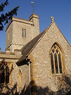
 Wootton Fitzpaine church | |
| Location | |
| Grid reference: | SY371957 |
| Location: | 50°45’29"N, 2°53’31"W |
| Data | |
| Population: | 345 (2011, parish) |
| Local Government | |
| Council: | Dorset |
| Parliamentary constituency: |
West Dorset |
Wootton Fitzpaine is a village in Dorset, some three miles north-east of Lyme Regis in a small side valley of the River Char, close to the Marshwood Vale.
The wider civil parish, though not the church parish includes Monkton Wyld to the west,[1] and at 2011 census had a recorded population of just 345 people, in 134 households.
The village
Wootton Fitzpaine consists primarily of two small centres: a larger western part comprising the village hall and about fifty densely placed houses, and a smaller eastern part comprising about a dozen houses, the church and manor house.[2]
The village is sited on Middle Lias and greensand and has a history of being agriculturally relatively prosperous.[3]
The village name derives from 'Wodetone', meaning a "Wood Farmstead", adding the name of the manorial family, Fitzpaine.[4]
The parish church was built mostly between the 13th and 15th centuries but was restored and added to in 1872.[5] It stands within the grounds of the adjacent Wootton House,[4] a three-storey brick-built house constructed around 1765 but also restored and added to in the late 19th century.[5]
The rectory dates from the end of the 15th century.[6]
Twenty structures within the parish are listed buildings.
Footpaths and trails
The Wessex Ridgeway and Monarch's Way long-distance footpaths pass through the parish, as does the Liberty Trail, a more local designated way.[2]
Outside links
| ("Wikimedia Commons" has material about Wootton Fitzpaine) |
References
- ↑ "Wootton Fitzpaine". Dorset OPC Project. 2013. http://www.opcdorset.org/WoottonFitzpaineFiles/WoottonFitzpaine.htm. Retrieved 11 November 2013.
- ↑ 2.0 2.1 "The Char Valley Village Communities Action Plans 2003. Wootton Fitzpaine Parish". http://www.charvalleypc.co.uk/action_plans/ap06.htm. Retrieved 12 November 2013. (Note: this document is also published by Dorset County Council at dorsetforyou.co.uk)
- ↑ Ralph Wightman (1983). Portrait of Dorset (4 ed.). Robert Hale Ltd. p. 160. ISBN 0 7090 0844 9.
- ↑ 4.0 4.1 "Wootton Fitzpaine". The Dorset Historic Churches Trust. http://www.dorsethistoricchurchestrust.co.uk/wotonftzpane.htm. Retrieved 11 November 2013.
- ↑ 5.0 5.1 An Inventory of the Historical Monuments in Dorset, Volume 1
- ↑ West Dorset Holiday and Tourist Guide. West Dorset District Council. c. 1983. p. 22.
