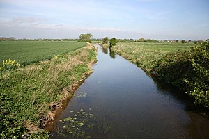
River Devon, Nottinghamshire

The River Devon is a tributary of the River Trent. It rises in Leicestershire and joins the Trent at Newark in Nottinghamshire.
The river has a catchment of 110 square miles and had an average flow of 30 million gallons a day, as once measured at the gauging station in Cotham, near the mouth. However, the gauging station was closed in 1978, due to doubts about the reliability of its measurements, and there is currently no gauging station on the river.
Course
The river rises as a series of springs and streams near the villages of Eastwell and Eaton in north-eastern Leicestershire, close to the 490-foot contour, and flows generally northwards. Passing close to Branston, it flows into Knipton reservoir, built in the 1790s to supply the Grantham Canal.[1] The surface area of the reservoir is 52 acres, and it feeds the canal through a channel, called The Carrier, which has open sections and runs through a tunnel for about a mile.[2]
The village of Knipton is a little further to the north, on the eastern bank of the river. An unnamed tributary flows through the village to join the river, after which it enters woodland, where it is joined by a stream flowing eastwards from a small lake called Frog Hollow. Belvoir upper lake and Belvoir lower lake come next, each covering 12 acres and created by the landscape architect Lancelot "Capability" Brown in the grounds of the Belvoir Castle estate. They are used for course fishing.[3] Between them, an early 19th century bridge with five arches and long retaining walls, built from ironstone and limestone, acts as a weir.[4]
After the lakes, the river passes to the east of Woolsthorpe-by-Belvoir and the hamlet of Stenwith, to flow under the Grantham Canal in a conduit.
The county border between Leicestershire and Lincolnshire follows the course of the river for a short distance near the bottom lake, and beyond Woolsthorpe, the river is in Lincolnshire.
Passing back into Leicestershire, the Devon flows through Muston and Bottesford, where there are a number of bridges. At the end of Church Street, Fleming's bridge is a double-arched Grade II listed medieval bridge, now just used by pedestrians, which was built for Samuel Fleming, who was rector in the village between 1581 and 1620.[5] At Devon Lane, there is a ford, besides which stands a single-arched brick bridge, with two holes passing through the spandrels, and iron railings in the centre of the parapet. It was built in the early 19th century.[6]
Beyond Bottesford, the river is crossed by four railway bridges, only one of which is still in use, carrying the line from Grantham to Nottingham. A fifth bridge, located in fields to the north of the village, consisting of three brick arches, carried the Newark to Leicester railway line over the river. It was opened in 1860, and ceased to be used for railway traffic in 1960. The centre arch collapsed after heavy rain in 2007, and the whole structure has been replaced by a single steel span, resting on the remains of two of the piers.[7]
The river again forms the county border, until it reaches Staunton in the Vale, which is in Nottinghamshire. The Winter Beck joins the west bank, as does the River Smite soon afterwards. The river passes Cotham which lies to the east, and runs close to a Civil War redoubt at Hawton,[8] to arrive at the outskirts of Newark-on-Trent.
At Newark, the Devon passes another civil war defence, the Queen's Sconce, built in 1644 at a strategic point overlooking the Devon, the Trent and the Great North Road. The site was bought by the local council in 1912, and formed part of Devon Park, which has since been extended by further acquisitions of land.[9]
Crossing under the B6166, which follows the course of the Fosse Way Roman road at this point, the Devon joins the River Trent. Below the bridge, the river is used for moorings, and there is a marina on the western bank. The mouth is below the 50-foot contour.
References
- ↑ Hadfield 1970, p. 61
- ↑ "Linear Walk 5". Grantham Canal. http://www.granthamcanal.com/leisure/lin5.htm. Retrieved 2011-06-15.
- ↑ "Belvoir Lakes". AJS Fisheries. http://www.ajsfisheries.co.uk/pages/belvoir.html.
- ↑ Images of England — details from listed building database (190009) Bridge between upper and lower lakes
- ↑ Images of England — details from listed building database (190046) Fleming's Bridge, Bottesford
- ↑ Images of England — details from listed building database (190049) Footbridge, Devon Lane, Bottesford
- ↑ Peggy Topps. "Bottesford Bridges". Bottesford Living History. http://www.bottesfordhistory.org.uk/page_id__142_path__0p4p72p.aspx. Retrieved 2011-02-27.
- ↑ "Hawton Reboubt". PastScape - National Monuments Record (322226). http://www.pastscape.org.uk/hob.aspx?hob_id=322226.
- ↑ "History of the Park". Friends of Sconce and Devon Park. http://www.sconceanddevonpark.org/index.php?option=com_content&task=view&id=13&Itemid=27. Retrieved 2011-06-15.
Books
- Hadfield, Charles (1970). The Canals of the East Midlands. David and Charles. p. 61. ISBN 0-7153-4871-X.