Sutton Weaver
| Sutton Weaver | |
| Cheshire | |
|---|---|
 Clifton Road, Sutton Weaver | |
| Location | |
| Grid reference: | SJ544794 |
| Location: | 53°18’36"N, 2°41’6"W |
| Data | |
| Population: | 495 (2011) |
| Post town: | Sutton |
| Postcode: | WA7 |
| Dialling code: | 01928 |
| Local Government | |
| Council: | Cheshire West & Chester |
| Parliamentary constituency: |
Eddisbury |
Sutton Weaver is a small village in Cheshire, two miles north-east of Frodsham.
According to the 2011 census, the wider parish had a population of 495, in 206 households.
In the 1870s, Sutton Weaver was described as:
- "SUTTON, a township in Runcorn parish, Cheshire; at Runcorn-Road r. station, 2 miles NE of Frodsham. It has a post-office under Preston-Brook. Acres, 1,181. Real property, £2,719. Pop., 356. Houses, 63. The manor belongs to the representatives of the late Sir A. J. Aston."[1] – John Marius Wilson (1870–72)
Transport links
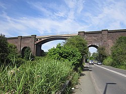
Directly south-west the village is enclosed via one of the London & North Western Railway lines, heading from north to south, under which the A557 leads through the railway bridge towards Beechwood, It is also directly linked to Frodsham by the A56.

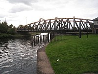
The Sutton Weaver Swing Bridge is situated on the A56 between the village of Sutton Weaver and the town of Frodsham. The present bridge was constructed in 1926 and is a vital transport link across the River Weaver.[2] The 90-year-old structure which carries an estimated 20,000 vehicles per day has been granted the go ahead for a £4.5 million upgrade.
Although it used to have its own railway station which opened on the 1 April 1869 and was situated on the east side of Station Road near to the railway bridge. The station closed to passengers in 1931 and completely closed in 1942.[3] The nearest train station to Sutton Weaver today is Runcorn East, two miles away.
Sutton Hall
Sutton Weaver only has one listed building, Sutton Hall is to the south of the village (SJ544790). It has been designated as a Grade I listed building.[4]
The hall dates from the late 15th century or the early 16th century, and it was extended in the late 17th century and in the early 19th century. It is built in brown brick in two storeys with attics. Internally there are two superimposed great halls which are a "feature of unique interest".
The associated barn and shippon, which date from the late 17th century are listed Grade II. Also listed Grade II is a circular feeding trough in the farmyard dating from the 19th century which is made from a single stone and measures almost six feet across and three feet high.
The hall is now a farmhouse, and the barn has been converted for residential use.[5]
Geography

The village is twelve miles from the county town, Chester.[6] The closest settlement include Brookvale, Preston Brook and Frodsham. Other local villages include Halton, Norton and Dutton.
Sutton Weaver Playground, just half an acre, has been enrolled as a Queen Elizabeth II Field.
| ("Wikimedia Commons" has material about Sutton Weaver) |
References
- ↑ Wilson, John (1870–72). "Imperial Gazetteer of England and Wales". Edinburgh: A. Fullarton and Co.. http://www.visionofbritain.org.uk/place/place_page.jsp?p_id=3406&st=sutton. Retrieved 16 March 2013.
- ↑ "Sutton Weaver Swing Bridge". Sutton Parish Council". http://www.suttonweaver.co.uk/#/sutton-weaver-bridge/4550789330. Retrieved 19 March 2013.
- ↑ "Nearest Station". Sutton Weaver Parish Council. http://www.suttonweaver.co.uk/#/then-now/4545522107. Retrieved 16 March 2013.
- ↑ National Heritage List 1253572: Sutton Hall
- ↑ "Sutton Hall". Sutton Parish Council". http://www.suttonweaver.co.uk/#/sutton-hall/4546226588. Retrieved 6 May 2013.
- ↑ "Distances". http://www.earthtools.org. Retrieved 16 March 2013.
