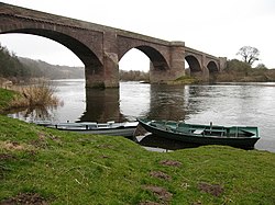
Ladykirk and Norham Bridge
| Ladykirk and Norham Bridge | |
| Berwickshire, Northumberland | |
|---|---|
 The Ladykirk and Norham Bridge | |
| Location | |
| Carrying: | Road traffic (B6470) |
| Crossing: | River Tweed |
| Location | |
| Grid reference: | NT890472 |
| Location: | 55°43’8"N, 2°10’34"W |
| Structure | |
| Material: | Stone |
| History | |
| Built 1885 – 1887 | |
| Information | |
The Ladykirk and Norham Bridge connects Ladykirk in Berwickshire with Norham in Northumberland across the River Tweed.
Earlier bridges
The previous bridge here was a timber trestle built between 1838 and 1839 by J. Blackmore.[1][2] The bridge was funded by subscribers purchasing shares; David Robertson, 1st Baron Marjoribanks paid £3000, and ten others paid £500 each.[3]
This wooden bridge used curved ribs, eight planks deep at the ends and three planks deep in the middle, where each individual plank was 6 inches deep.[4] These were used to create two arches, each of 190-foot span and 17-foot rise. Each arch was supported by two trusses.[4] The planks were 18 feet long, and no piece of timber in the bridge was longer than 28 feet.[4] The roadway was 18 feet wide.[4] The entire bridge was restored in 1852, with the exception of the stone piers.[3]
History
Construction of the present stone bridge lasted from 1885 to 1887.[1] The bridge is listed at Grade II by English Heritage and at Category B by Historic Environment Scotland.[1][5]
The bridge was designed by Thomas Codrington and Cuthbert A. Brereton for the Tweed Bridges Trust.[5]
Design
It is a late stone road arch bridge with four spans.[5] The two middle arches are of 90-foot span, and the outer two of 85-foot span, and the width of the roadway between the parapets is 14 feet.[5] The outer piers have triangular cutwaters, but the central pier has a curved cutwater that continues up to the height of the road, with a break in the parapet to create a refuge for pedestrians.[6]
The bridge uses dressed-stone for the arch rings, and has coursed-rubble spandrels and wing walls.[6] It is built from red sandstone, and faced with ashlar dressings.[1] The spandrels are hollow to reduce the load on the arches, an innovation by Thomas Telford.[1][7]
The bridge carries the B6470 public road between the villages of Ladykirk in Berwickshire and Norham in Northumberland.[1] It is just downstream of a river island in the Tweed.
| ("Wikimedia Commons" has material about Ladykirk and Norham Bridge) |
References
- ↑ Jump up to: 1.0 1.1 1.2 1.3 1.4 1.5 CANMORE (RCAHMS) record of Ladykirk And Norham Bridge
- ↑ "Ladykirk and Norham Bridge". bridgesonthetyne.co.uk. http://www.bridgesonthetyne.co.uk/norham.html. Retrieved 10 September 2014.
- ↑ Jump up to: 3.0 3.1 Report of the Commissioners for Inquiring into Matters Relating to Public Roads in Scotland. Murray and Gibb. 1859. p. 132. http://books.google.com/books?id=flE3AAAAMAAJ&pg=PA132.
- ↑ Jump up to: 4.0 4.1 4.2 4.3 Warr, George Finden (1851). Dynamics, Construction of Machinery, Equilibrium of Structures and the Strength of Materials. Robert Baldwin. pp. 176–177. http://books.google.com/books?id=qSMJAAAAIAAJ&pg=PA176.
- ↑ Jump up to: 5.0 5.1 5.2 5.3 "Ladykirk and Norham Bridge". sine.ncl.ac.uk. http://sine.ncl.ac.uk/view_structure_information.asp?struct_id=1438. Retrieved 9 September 2014.
- ↑ Jump up to: 6.0 6.1 Historic Border Bridges
- ↑ "Ashford Carbonell Bridge". engineering-timelines.com. http://www.engineering-timelines.com/scripts/engineeringItem.asp?id=750. Retrieved 10 September 2014.